
Country Canada RCM La Matapédia Time zone EST (UTC-5) Area 625.8 km² Province Québec | Region Bas-Saint-Laurent Constituted unspecified Area code(s) 418 and 581 Population 15 (2011) | |
 | ||
Routhierville is an unorganized territory in the Bas-Saint-Laurent region of Quebec, Canada. The territory is bisected by the Matapédia River and Quebec Route 132 that runs parallel to it. There are two hamlets in the territory: the eponymous Routhierville () and Milnikek ().
Contents
Map of Routhierville, QC, Canada
The community of Routhierville is located on the west bank of the Matapédia River along the Canadian National Railway that was originally constructed as the Intercolonial Railway in the 1860s, while its train station was built in 1878. The community used to be called Assametquagan, meaning "appearing at the detour", but renamed after station master Alphonse Routhier (1875-1958).
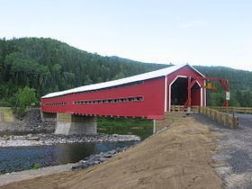
The community of Routhierville is accessible from Route 132 with a covered bridge over the Matapédia River, built in 1931 to replace a ferry. This 78.5 metres (258 ft) long and 6.3 metres (21 ft) wide bridge was classified as a historic monument on October 1, 2009, and rebuilt in 2011.
Demographics
Population trend:
Private dwellings occupied by usual residents: 8 (total dwellings: 15)