
District Alzey-Worms Elevation 172 m (564 ft) Area 5 km² Dialling code 06732 | Time zone CET/CEST (UTC+1/+2) Postal code 55286 | |
 | ||
Rommersheim is a Stadtteil (quarter) of the town Wörrstadt in Rheinhessen in the German state Rheinland-Pfalz. It lies in a valley south-west of Wörrstadt.
Contents
- Map of Rommersheim 55286 WC3B6rrstadt Germany
- History
- Culture and places of interest
- Buildings
- Places of interest outside the village
- Public facilities
- References
Map of Rommersheim, 55286 W%C3%B6rrstadt, Germany
History
Originally, Rommersheim was called Eichloch. Eichloch is documented the first time 824. January 15, 1931 the village Eichloch has been renamed Rommersheim, after a supposed abandoned nearby village. November 7, 1970 Rommersheim with then 432 inhabitants became a suburb of Wörrstadt.
Culture and places of interest
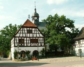
The Nachrichtliches Verzeichnis der Kulturdenkmäler Rheinland-Pfalz für den Landkreis Alzey-Worms of Generaldirektion Kulturelles Erbe list in particular the following heritage sites in Rommersheim
Buildings
Places of interest outside the village
Public facilities
The Neubornschwimmbad is an open air public swimming pool, located between Rommersheim and Wörrstadt.
References
Rommersheim (Wörrstadt) Wikipedia(Text) CC BY-SA