
Country Philippines Province Romblon Founded 1571 (as encomienda) Area 86.87 km² Area code 42 | Region MIMAROPA (Region IV-B) District Lone district Barangays Population 38,758 (2015) Dialling code 42 | |
 | ||
Neighborhoods Lonos, Agnipa, Macalas, Agbaluto Points of interest Calamian Islands, Bon Bon Beach, Fort San Andres, Talipasak Beach Resort, El Krimphoff Resort | ||
Romblon is a third-class municipality and capital of Romblon province. In the 2015 census, it had a population of 38,758 inhabitants. Romblomanon or Ini is the native language of its residents.
Contents
- Map of Romblon Philippines
- Early history
- Modern history
- Geography
- Barangays
- Demographics
- Local government
- Provincial Government
- By sea
- By air
- Tourism
- References
Map of Romblon, Philippines
Early history
Romblon Island, seat of the municipality of Romblon, is one of the three major islands of Romblon province. The islands were first visited by Spanish conquistador Martin de Goiti in late 1569, and were thereafter organized by the Spanish into encomiendas. The encomienda of Donblon (Romblon), established on April 24, 1571, was granted to Don Gonzalo Riquel. In the first census done by Spanish navigator Miguel de Loarca in 1582, Romblon Island was shown to have 240 residents engaged in wax gathering.
In 1631, during the term of Spanish Governor-General Juan Niño de Tabora, Romblon was established as a pueblo, making it one of the two oldest settlements in the province, the other being Banton located in the north of the province. It received its first Spanish missionaries in the 17th century. During the 17th and 18th centuries, it was often ravaged by Moros.
It was organized into a Comandancia (a province or district under military control) by the Spanish in 1853.
Modern history
In 1901, the American occupation saw the establishment of a civilian government in the town. Ten new barrios were created while three existing barrios were also abolished. These include Aglomiom which was merged to Sablayan due to its small population, Embarcacion which was attached again to El Pueblo or Poblacion and the inland barrio of Cogon which was reorganized and split into five barrios of Tambac, Ilauran, Macalas, Lamao, and Agbaluto (referred collectively as TIMLA, from its initial letters) while barrio Alfonso XIII was renamed Calabogo.
The ten additional barrios were Bagacay, Agbudia, Agtongo, Embarcacion, Maria Cristina (renamed as Sawang) and the five new TIMLA barrios. These barrios aside from TIMLA were Agtongo which was created into a separate barrio in 1916 taken from Cajimos while in 1918 those engaged in maritime industry which were designated separately as distinct barrio known as Embarcacion was annexed again to barrio Poblacion or El Pueblo in 1939. Agbudia was the last barrio to be created taken from Guimpingan in 1939. Meanwhile, the two barrios Majabangbaybay and Sogod, located in Tablas island, were returned to Badajoz (now San Agustin), abolished as independent barrios and attached as sitios of barrio Guinpuc-an (Carmen) in 1901.
During World War II, an American force landed in the island on March 11, 1945 and liberated it from the occupying Japanese forces. By March 18, the entire province was liberated from the Japanese. A monument located near the beach in Sawang commemorates this event.
In 1960, the island barrio of Nagoso was renamed Cobrador while in 1975, the urban barangay of Poblacion was split into four separate barangays, named simply as Barangays 1, 2, 3, and 4.
Geography
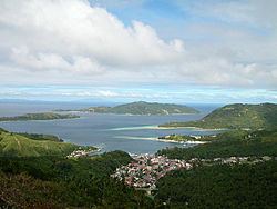
The municipality consists primarily of Romblon Island, as well as the smaller Alad, Cobrador, and Logbon Islands. The municipality is situated along the coast of Romblon Bay, a natural harbor and safe haven for ships passing in the area during inclement weather. The highest peak is Mount Lagting in barangay Sablayan with a height of 444 metres (1,457 ft).
Barangays
Romblon is politically subdivided into 31 barangays.
Demographics
Romblomanons are the indigenous inhabitants of Romblon. They are part of the wider Visayan ethnolinguistic group, who constitute the largest Filipino ethnolinguistic group. In 2015, there were 38,758 people living in Romblon. Most Romblomanons speak Ini, one of the three languages in the province after Asi and Onhan.
Local government
Pursuant to Chapter II, Title II, Book III of Republic Act 7160 or the Local Government Code of 1991, the municipal government is composed of a mayor (alkalde), a vice-mayor (bise alkalde) and members (kagawad) of the legislative branch Sangguniang Bayan alongside a secretary to the said legislature, all of which are elected to a three-year term and are eligible to run for three consecutive terms. The incumbent mayor is Mariano M. Mateo and the vice mayor is Mac-Mac Silverio. Both are from Nacionalista Party.
Provincial Government
As the capital of the province, the Romblon Provincial Capitol is situated in the municipality, where the governor, the vice governor, and the Sangguniang Panlalawigan takes office. It is located in Barangay Capaclan.
By sea
Romblon is accessible via RORO vessels that ply the Manila-Odiongan, Batangas City-Odiongan, or the Roxas-Odiongan route. From Odiongan, Romblon can be reached by jeepney and motorized boat via San Agustin, Romblon. There are also direct RORO routes from Manila to Romblon as well as Batangas City and Romblon.
By air
The closest airport with active airline service is Tugdan Airport in Alcantara, Romblon. As of August 2014, Fil-Asian Airways offers four weekly flights while SkyJet offers charter flights to Romblon from Manila. From Alcantara, Romblon can be reached in 3–4 hours by jeepney and an hour by motorized boats from San Agustin.
Tourism
The capital town of Romblon is rich political and religious history as well as natural beauty. Some of the places worth visiting in the municipality include: