
- location Polk County, Oregon - elevation 322 ft (98 m) Mouth South Yamhill River | - elevation 1,945 ft (593 m) Length 9.7 km Country United States of America | |
 | ||
- location Grande Ronde, Polk County, Oregon | ||
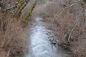
The Rogue River is a tributary of the South Yamhill River in Polk County, Oregon, United States. It enters the South Yamhill about 1,000 feet (300 m) north of Grand Ronde. It is sometimes referred to as Rogue Creek.
Map of Rogue River, Oregon, USA
It was named for the Rogue River Indians who lived along its banks after they were forced to move from Southern Oregon to the nearby Grand Ronde Indian Reservation.
Its headwaters are on the northeast face of Saddleback Mountain, elevation 3,004 feet (916 m).
References
Rogue River (South Yamhill River) Wikipedia(Text) CC BY-SA