
Country United States FIPS code 24-67400 Elevation 3 m Population 1,307 (2013) Area code 410 | Time zone Eastern (EST) (UTC-5) GNIS feature ID 0586872 Zip code 21661 Local time Monday 7:43 PM | |
 | ||
Weather 9°C, Wind SW at 3 km/h, 47% Humidity Area 4.014 km² (3.471 km² Land / 54 ha Water) | ||
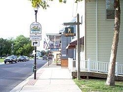
Rock Hall, "The Pearl of the Chesapeake", is a waterfront town located directly on the National Chesapeake Scenic Byway in Kent County, Maryland, United States. It is located less than two hours away from large metropolitan areas such as Philadelphia, Baltimore and Washington DC. The population was 1,310 at the 2010 census.
Contents
- Map of Rock Hall MD 21661 USA
- History
- Geography
- 2010 census
- 2000 census
- Economy
- Government
- Arts and culture
- Notable people
- References
Map of Rock Hall, MD 21661, USA
History
Originally called Rock Hall Crossroads, the town is now a quaint fishing, sailing and recreational boating town situated picturesquely on the upper Eastern Shore of the Chesapeake Bay. It is the center of Kent County’s maritime industries and is also a popular destination for art, music, culture and wildlife enthusiasts. Even before the Town’s establishment in 1707, the Chesapeake Bay and its tributaries have shaped the economic and cultural development of the Town. In the early years, the Bay served as a commercial link to other populated areas on the western shore, such as Baltimore, Annapolis and Virginia, as well as northern areas such as Philadelphia and New York.
The town was named for a mansion made of white sandstone, and was incorporated in 1908.
Rock Hall served as a shipping point for tobacco, seafood and other agricultural products, as well as a passenger transport connection for travelers during the Colonial era. Famous Americans, such as George Washington, James Madison and others have passed through Rock Hall numerous times traversing between Virginia and their northbound destinations. Later, fishing and seafood processing became the Town’s largest industry, providing an economic base for commerce and town community life. Maryland blue crabs, oysters, rockfish and more, although less plentiful today, have comprised the bountiful seasonal harvests of the Upper Chesapeake Bay. Rock Hall Harbor continues to be a working harbor with an active fleet of commercial watermen who leave the dock each day. Rock Hall has three museums including a Waterman's museum. This is presently located in the Town Hall with many artifacts to preserve the heritage of the iconic way of life associated with the Chesapeake Bay waterman. In recent years, recreational interests, shopping and tourism have emerged as a strong economic transformation with Rock Hall serving as one of the larger charter boat fishing and sailing centers on the Eastern Shore.
Hinchingham and Trumpington are listed on the National Register of Historic Places.
Geography
According to the United States Census Bureau, the town has a total area of 1.55 square miles (4.01 km2), of which, 1.34 square miles (3.47 km2) is land and 0.21 square miles (0.54 km2) is water.
2010 census
As of the census of 2010, there were 1,310 people, 630 households, and 374 families residing in the town. The population density was 977.6 inhabitants per square mile (377.5/km2). There were 930 housing units at an average density of 694.0 per square mile (268.0/km2). The racial makeup of the town was 92.0% White, 5.8% African American, 0.2% Asian, 0.1% from other races, and 1.9% from two or more races. Hispanic or Latino of any race were 1.5% of the population.
There were 630 households of which 19.2% had children under the age of 18 living with them, 43.5% were married couples living together, 11.4% had a female householder with no husband present, 4.4% had a male householder with no wife present, and 40.6% were non-families. 35.9% of all households were made up of individuals and 19.7% had someone living alone who was 65 years of age or older. The average household size was 2.05 and the average family size was 2.57.
The median age in the town was 54.3 years. 15.2% of residents were under the age of 18; 5.3% were between the ages of 18 and 24; 16.4% were from 25 to 44; 33% were from 45 to 64; and 30% were 65 years of age or older. The gender makeup of the town was 47.2% male and 52.8% female.
2000 census
As of the census of 2000, there were 1,396 people, 654 households, and 408 families residing in the town. The population density was 1,050.3 people per square mile (405.3/km²). There were 834 housing units at an average density of 627.5 per square mile (242.1/km²). The racial makeup of the town was 92.91% White, 5.52% African American, 0.07% Native American, 0.14% Asian, 0.07% Pacific Islander, 0.14% from other races, and 1.15% from two or more races. Hispanic or Latino of any race were 0.86% of the population.
There were 654 households out of which 23.1% had children under the age of 18 living with them, 47.6% were married couples living together, 11.9% had a female householder with no husband present, and 37.5% were non-families. 32.4% of all households were made up of individuals and 19.7% had someone living alone who was 65 years of age or older. The average household size was 2.13 and the average family size was 2.67.
In the town, the population was spread out with 19.8% under the age of 18, 5.5% from 18 to 24, 21.3% from 25 to 44, 29.5% from 45 to 64, and 23.9% who were 65 years of age or older. The median age was 47 years. For every 100 females there were 87.1 males. For every 100 females age 18 and over, there were 84.2 males.
The median income for a household in the town was $32,833, and the median income for a family was $38,672. Males had a median income of $29,375 versus $21,429 for females. The per capita income for the town was $20,521. About 10.5% of families and 13.2% of the population were below the poverty line, including 22.4% of those under age 18 and 10.0% of those age 65 or over.
Economy
The Greater Rock Hall Business Association supports and promotes an eclectic array of retail shops that are located on the Main St.shopping area and an all-new Rock Hall Village located at the end of the street. The Association also supports a wide variety of valuable and entertaining annual events and activities for people of all ages. Among them are "Best of the Bay" award-winning Fourth of July festivities, a Fall festival, and a very popular town wide "Pirates and Wenches Fantasy Weekend" in August.
Government
The town has a Weak Mayor-Council-Manager form of government. As of 2016, the mayor is Brian L. Jones.
Arts and culture
Among other attractions, the Town of Rock Hall is now home port to a wide variety of award-winning marinas, marine services, restaurants, fishing and sailing charters, kayak rentals, bed and breakfasts, wild life refuge, new and used sail and power boat dealerships and more. The newest of the County's parks and public landings, Bayside Landing Park is located off of Bayside Avenue in Rock Hall and is centered along the Rock Hall Harbor. The park offers a public swimming pool, public restroom facilities and deep water and dual boat ramps which provide direct access to the Chesapeake Bay. Rock Hall’s small swimming beach and gazebo, known locally as Ferry Park, is located on Beach Road. With picnic tables, barbecue stands, and pavilions, it offers outstanding views from the Chesapeake Bay to the western shore and allows one to experience some of the best sunsets imaginable.