
 | ||
The River Hayle (Cornish: Heyl, meaning estuary) is a small river in west Cornwall, England, UK which issues into St Ives Bay at Hayle on Cornwall's Atlantic coast.
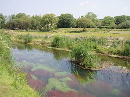
The River Hayle is approx 12 miles (19 kilometres) long and it rises south-west of Crowan village. Its course is west for approx 5 miles (which brings the river to within 3 miles of the south coast at Marazion on Mount's Bay). It then flows through a steep wooded valley north of the granite high ground at Trescowe Common, formerly a mining area, before turning abruptly north near the hamlet of Relubbus. It then follows a northerly course for the remaining six miles to the estuary and passes St Erth.
The Hayle Estuary encompasses a disused port on the east bank and a substantial area of salt marsh named Lelant Saltings to the west. The port was once of considerable importance to Hayle's industry (see main article Hayle). Lelant saltings is an important habitat for birds and the Royal Society for the Protection of Birds runs a nature reserve there. Areas around the estuary are designated as sites of special scientific interest (see also Hayle SSSI).