
Population 929 (2011) Sovereign state United Kingdom UK parliament constituency Grantham and Stamford | OS grid reference TF098278 | |
 | ||
Rippingale is a village and civil parish in the South Kesteven district of Lincolnshire, England. The population of the civil parish was 929 at the 2011 census. The village is situated on the A15 road, about 5 miles (8 km) north from Bourne.
Map of Rippingale, Bourne, UK
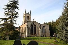
Rippingale is part of the Ringstone in Aveland group of parishes, in the Aveland Deanery of the Diocese of Lincoln. The incumbent is Linda Pugh. St Andrew's parish church dates from the thirteenth and fourteenth century, though the tower dates from a century later. In the church yard was located a weeping ash, Fraxinus excelsior 'Pendula' – a tree rare for Britain. It survived for a century until 2002 – having died it was felled.
The village public house is The Bull Inn. A railway station on a line between Bourne and Sleaford opened in 1871 for goods and closed in 1964; regular passenger services lasted from 1872 to 1930. The Church of England Primary School closed in July 2007, and the post office around the same time.
Rippingale falls within the drainage area of the Black Sluice Internal Drainage Board.
South of the village is the site of Ringstone, a lost village, which dates from before the Norman conquest and which survived into the 19th century as Ringstone Hall.TF094270
Rippingale has a village design statement produced by a Village Design Statement Committee. The committee was established to produce guidance for South Kesteven District Council (SKDC). The statement was adopted in 2002.