
Length 8 km | River mouth Atlantic Ocean | |
 | ||
Main source Gudo de Cavaleiro,Santo Antão | ||
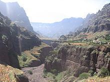
Ribeira da Garça is a river in the northern part of the island of Santo Antão in Cape Verde. Its source is on the north side of the main range of the island. It flows north through the settlements of Garça de Cima and Chã de Igreja and the west of the municipality of Ribeira Grande, and drains into the Atlantic Ocean in the north nearly 10 km west of Ribeira Grande. Hamlets located near or by the stream includes Horta da Garça, Cagarra, Manta Velha and Fundo. Parts of the river features some cliffs that are 30 to 40 meters high.
The stream starts in Lombo de Gudo as Cabuco Dragum located north of Gudo dos Moroços (1,604 m) inside Moroços Natural Park, it is also north of Gudo de Cavaleiro (1,810 m).
Midway in the area where the reservoirs stands is a mountain to the east and further east is the source of Ribeira Grande.
Canto de Cagarra Dam
The Canto de Cagarra Dam (Barragem de Canto de Cagarra) has been constructed and was finished on November 16, 2014, the only large dam on the island located roughly in the middle of the stream. The reservoir is predominantly dry and are being the two in Cape Verde, the other is Salineiro on the Ribeira Grande de Santiago north of Cidade Velha on Santiago Island.
Hurricane Fred filled up Canto de Cagarra dam on September 2015 and irrigated drought-stricken lands.