Suvarna Garge (Editor)

Rhone–Rhine Canal

Updated on
Edit
Like
Comment
Share on FacebookTweet on TwitterShare on LinkedInShare on Reddit
Country
  
France

Rhone–Rhine Canal httpsuploadwikimediaorgwikipediacommonsthu

Similar
  
Canal de Bourgogne, EV6 The Rivers Route, Écluse de Kembs‑Niffer, Ill, Gare de Strasbourg

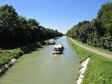
The Rhone–Rhine Canal is a significant waterway of France, that can be considered to connect the Rhine and the Rhone and thereby the North Sea and the Mediterranean.

Map of Canal du Rh%C3%B4ne au Rhin, France

There are a number of parts to the canal:

  • a) The 224-km-long Canal du Rhone au Rhin connects from the Saône near Saint-Jean-de-Losne through to Mulhouse. It incorporates river sections of the Doubs.
  • b) The 13-km-long large-scale Embranchement Kembs-Niffer (formerly part of the Canal de Huningue) that continues the canal and which connects the docks at Mulhouse with the Grand Canal d'Alsace, which is the lateral, canalised Rhine, at Niffer.
  • c) The 29-km-long section, formerly part of the Northern arm of the Canal du Rhone au Rhine, that connects from the Rhine near Boofzheim to Strasbourg. The intervening section, between Boofzsheim and Mulhouse has been closed to navigation.
  • d) A 3-km-long section of the former Canal de Huningue, from Niffer to Kembs. The remainder of that canal, from Kembs to Basel has been closed, superseded by the navigationally improved and canalised Rhine.
  • The canal was originally planned from 1784 onwards but finally opened in 1834, although the River Doubs which it incorporated has been significant since earliest times. Changes happened in 1960, with the opening of the enlarged Kembs-Niffer branch at the eastern end and the closure of part of the northern arm. A major project to substantially increase the size of the whole canal to accommodate Rhine-size commercial traffic was abandoned in 1997 and part of the allocated funds were used to modernise navigation on the canal.

    References

    Rhone–Rhine Canal Wikipedia


    Similar Topics