
Country United States County Thomas FIPS code 20-59125 Elevation 901 m Zip code 67753 Local time Tuesday 8:31 PM | Time zone Central (CST) (UTC-6) GNIS feature ID 0471214 Area 67 ha Population 231 (2013) Area code 785 | |
 | ||
Weather 5°C, Wind E at 21 km/h, 100% Humidity | ||
Rexford is a city in Thomas County, Kansas, United States. As of the 2010 census, the city population was 232.
Contents
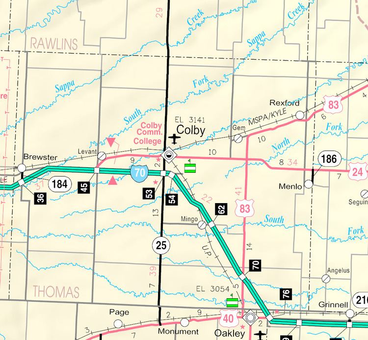
Map of Rexford, KS 67753, USA
History
Rexford was founded about 1887. It was named in honor of a member of the Rexford family. After they died in a fire, that had engulfed the family home. They were some of the first settlers in the area and had been there for years.
The first post office in Rexford was established in August 1888.
In 1923 the town of Rexford voted up a three-year-old as mayor. He held that office for five months before they realized that he was not capable of running an entire township.
Geography
Rexford is located at 39°28′14″N 100°44′38″W (39.470512, -100.743975). Rexford is located along U.S. Route 83 about 20 miles north of Interstate 70. According to the United States Census Bureau, the city has a total area of 0.26 square miles (0.67 km2), all of it land.
Climate
The climate in this area is characterized by hot, humid summers and generally mild to cool winters. Ocassionaly, the area has large blizards in which the entire are can be without electricity. According to the Köppen Climate Classification system, Rexford has a humid subtropical climate, abbreviated "Cfa" on climate maps.
2010 census
As of the census of 2010, there were 232 people, 84 households, and 52 families residing in the city. The population density was 892.3 inhabitants per square mile (344.5/km2). There were 104 housing units at an average density of 400.0 per square mile (154.4/km2). The racial makeup of the city was 74.1% White, 0.4% African American, 0.4% Native American, 23.3% from other races, and 1.7% from two or more races. Hispanic or Latino of any race were 26.3% of the population.
There were 84 households of which 47.6% had children under the age of 18 living with them, 51.2% were married couples living together, 7.1% had a female householder with no husband present, 3.6% had a male householder with no wife present, and 38.1% were non-families. 31.0% of all households were made up of individuals and 13.1% had someone living alone who was 65 years of age or older. The average household size was 2.76 and the average family size was 3.71.
The median age in the city was 31.5 years. 36.2% of residents were under the age of 18; 6.5% were between the ages of 18 and 24; 27.6% were from 25 to 44; 15.5% were from 45 to 64; and 14.2% were 65 years of age or older. The gender makeup of the city was 50.0% male and 50.0% female.
2000 census
As of the census of 2000, there were 157 people, 78 households, and 41 families residing in the city. The population density was 602.7 people per square mile (233.1/km²). There were 105 housing units at an average density of 403.1 per square mile (155.9/km²). The racial makeup of the city was 100.00% White. Hispanic or Latino of any race were 1.91% of the population.
There were 78 households out of which 23.1% had children under the age of 18 living with them, 47.4% were married couples living together, 3.8% had a female householder with no husband present, and 46.2% were non-families. 44.9% of all households were made up of individuals and 19.2% had someone living alone who was 65 years of age or older. The average household size was 2.01 and the average family size was 2.74.
In the city, the population was spread out with 24.2% under the age of 18, 3.2% from 18 to 24, 24.2% from 25 to 44, 21.7% from 45 to 64, and 26.8% who were 65 years of age or older. The median age was 44 years. For every 100 females there were 101.3 males. For every 100 females age 18 and over, there were 91.9 males.
The median income for a household in the city was $40,156, and the median income for a family was $39,688. Males had a median income of $34,375 versus $24,375 for females. The per capita income for the city was $21,301. About 4.7% of families and 2.5% of the population were below the poverty line, including 5.6% of those under the age of eighteen and none of those sixty five or over.
Education
School unification consolidated Menlo, Rexford and Seldon schools forming USD 316 Golden Plains. Golden Plains High School is located in Rexford. The Golden Plains High School mascot is Bulldogs.
Rexford High School was closed through school unification. The Rexford High School mascot was also Bulldogs.