
Elevation 708 m | Mountain range Swabian Jura | |
 | ||
Similar Stuifen, Hohenstaufen, Drei Kaiserberge, Kornbühl, Jusi | ||
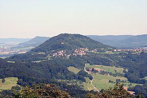
The Rechberg (el. 707.9 m.) is one of the three Imperial mountains near Göppingen in Baden-Württemberg in southern Germany. Together with the Hohenstaufen and Stuifen, it forms the so-called "Three Kaiser mountains" (Drei Kaiserberge).
Map of Rechberg, 73529 Schw%C3%A4bisch Gm%C3%BCnd, Germany
It lies south of Schwäbisch Gmünd on the northern end of the Schwäbische Alb. The other two Imperial mountains are the Stuifen to the southeast and the Hohenstaufen to the west. In 1979, the Rechberg was made a state recreation area.
The plateau at the summit is topped by a Baroque pilgrim's chapel built in 1686-88 by Count Bernhard Bero von Rechberg. Since the 15th century, the Rechberg has been the goal of pilgrimages.
On the west shoulder of the mountain about 100 m from the summit are the ruins of the Hohenrechberg. This castle was built in the time of the Hohenstaufen emperors by the counts of Rechberg and was the administrative center of their domain.