
Country India PIN 622 506 Population 3,257 (2001) Area code 914333 | Time zone IST (UTC+5:30) Telephone code 914333 Local time Saturday 3:59 PM | |
 | ||
Weather 34°C, Wind E at 16 km/h, 43% Humidity | ||
Rayavaram (Tamil: இராயவரம்) is a village in Pudukkottai district in Tamil Nadu, India.
Contents
Map of Rayavaram, Tamil Nadu
Geography
Rayavaram lies 72 kilometres (45 mi) south of Tiruchirappalli and 90 kilometres (56 mi) north of Madurai. The nearest town is Pudukkottai. The closest airport is at Tiruchirappalli. It is well connected by road and has at least 75 buses covering surrounding areas.
The village's economy is based on agriculture.
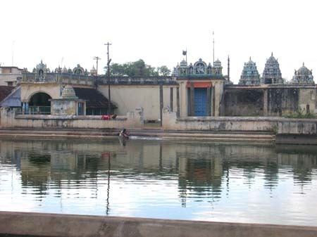
Water bodies
The village has several oorani (small tanks) and kanmai (vast spans of water storage) like Rayavaram Kanmai, Chettipatti Kanmai, Palayaoorni, Puduroorani and Nallanchetti Oorani, Olagankathan, Ponachi, Narayanan Chetti Oorani, Poochetti Oorani, Nalanchetti Oorani, Ayyanar kovl Oorani, Koththathi Kanmai, Kurunthangudi Kanmai, Ayungudi Kanmai, Aalangudi Kanmai and Valayan vayal Kanmai.
Temples
The village has several temples, including:
Rayavaram was the first village to allow low-class people entry to temples.
In the harvest season of May, Muthumariamman temple has a 10-day temple festival.
Demographics
As of 2001, Rayavaram had a population of 3257. Males constituted 49% of the population and females 51%. Rayavaram had an average literacy rate of 75%, higher than the national average of 59.5%; with 54% of the males and 46% of females literate. 12% of the population was under 6 years of age.
Education
The following educational institutions are in Rayavaram.
G.S.S Primary school