
Country Ireland Time zone WET (UTC+0) Elevation 148 m Province Leinster | County South Dublin Irish Grid Reference O019268 Local time Saturday 2:53 AM | |
 | ||
Website www.rathcoolevillage.com Weather 3°C, Wind E at 5 km/h, 94% Humidity | ||
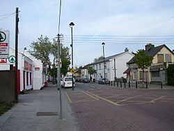
Rathcoole (Irish: Rath Cúil, meaning "ringfort of Comhaill") is a suburban village, south west of the city of Dublin. It lies near Newcastle, in South Dublin, Ireland. It lies just off the N7 national primary road. It borders the nearby village of Saggart.
Contents
- Map of Rathcoole Co Dublin Ireland
- Geography
- Name
- Representation
- Education
- Amenities
- Sport
- Twinned town
- References
Map of Rathcoole, Co. Dublin, Ireland
Geography
There is a park maintained by South Dublin County Council at the eastern end of the Village. Beechwood Lawns is located in between the main street and the park. Forest Hills is the single largest housing development in Rathcoole, lying between Beechwood Lawns and the western end of the village estate of Rathlawns and Tootenhill.
Name
Rath is the Irish word for a ringfort, often erected by wealthy farmers or local chiefs. There are several forts in the parish of Rathcoole, and while there is no definite explanation for the name 'Rathcoole,' it could well be Rath Comhaill meaning 'the rath of Comhaill', the father of Fionn. Coole may also come from the Irish word for forest, 'coill'. The rath associated with Rathcoole is in a field between Rathcoole and Saggart.
Representation
Rathcoole is in the Dublin Mid-West constituency and in the Clondalkin Local electoral area for county council elections (with Clondalkin, Newcastle and Saggart).
Education
Holy Family Community School at the western end of the village recently celebrated its twenty-fifth anniversary. It is a secondary school for students from Rathcoole and those commuting from the nearby towns of Clondalkin and Tallaght and the villages of Saggart and Brittas. There is also Holy Family National School located at the western end of Forest Hills and a Gaelscoil in Rathcoole Village.
Amenities
Rathcoole has a well-maintained and landscaped park run by South Dublin County Council and a local community centre which caters for local events and training courses.
One of Rathcoole's best known pubs is An Poitin Stil, which is built on the site of an original inn house dating back to 1649. The other pubs in the area are Muldowneys, Baurnafea House, and The Rathcoole Inn.
Sport
Rathcoole is perhaps best known for its former Olympic medal-winning swimmer, Michelle Smith, who won three gold medals and, also, a bronze medal at the 1996 Summer Olympic Games in Atlanta. The Rathcoole football club is known as "Rathcoole Boys". The well-known GAA club "Commercials Hurling Club" is located just off the Naas Road. The local basketball club is known as "Rathcoole Rockets". Rathcoole is close to a number of golf courses: Slade Valley, Citywest and Beech Park.
Coolmine Equestrian Centre was established here in 1989 and has since become one of the most well renowned Equestrian Facilities in Ireland. Horse riding lessons and guided horseback trips are available here in addition to a thriving equestrian education institution. Coolmine Equestrian Website
This equestrian centre welcomes international guests here on educational programmes, work experience and holidays. The centre became an Equestrian Academy and is now known locally as CEAD-Ireland. This Academy hosts festivals during the summer nicknamed the CEAD-Fest providing a celebration of the Irish Horse with dance, music, pony rides, pet farms, dog shows and equestrian competitions. cead-ireland.com