
Vehicle registration RA | Time zone CET (UTC+1) Population 227,111 (31 Dec 2008) | |
 | ||
Points of interest Schloss Rastatt, Schloss Favorite, Merkur, Rhine, Schwarzwaldhochstraße Destinations | ||
Rastatt is a district (Kreis) in the west of Baden-Württemberg, Germany. Neighboring districts are (from north clockwise) Karlsruhe, Calw, Freudenstadt and the Ortenaukreis. To the west it borders the French département Bas-Rhin. Rastatt completely surrounds the district-free city Baden-Baden.
Contents
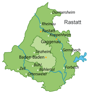
Map of Rastatt, Germany
History
The district was created in 1939 as the successor of the Oberamt Rastatt and later the Großkreis Baden. In 1973 it was merged with the majority of the neighboring district Bühl, and some small parts of the district Kehl.
Geography
The district is located in the Rhine valley. The south-east part, however, is part of the Northern Black Forest. The highest elevation is the Hornisgrinde.
The county has three small exclaves within the borough of Baden-Baden. The largest of these is home to the Waldenecksee, the smallest, the old abbey of Fremersberg.
Partnerships
Since 1968 the district has partnership with the Finnish city Vantaa. The partnership with the Italian Provincia di Pesaro e Urbino was started in 1996. It is twinned with Fano in Italy, New Britain, Connecticut in the USA and also twinned with Woking, England in 2000. It is also twinned with the Czech town from which its Princess came from during the Baroque period and for whom the summer palace was built.