
Country Philippines Founded 1902 Time zone PST (UTC+8) Local time Saturday 5:38 AM | District 2nd district Barangays Area 155.3 km² Province Albay | |
 | ||
Region Bicol Region (Region V) Weather 26°C, Wind NE at 5 km/h, 93% Humidity | ||
Rapu-Rapu, officially the Municipality of Rapu-Rapu (Central Bikol: Banwaan kan Rapu-Rapu; Filipino: Bayan ng Rapu-Rapu), is a municipality in the province of Albay in the Bicol Region (Region V) of the Philippines. The population was 36,920 at the 2015 census. In the 2016 electoral roll, it had 19,243 registered voters.
Contents
- Map of Rapu Rapu Albay Philippines
- History
- Geography
- Climate
- Barangays
- Demographics
- Government
- Education
- References
Map of Rapu-Rapu, Albay, Philippines
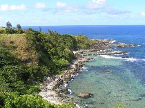
The municipality comprises three islands: Rapu-rapu Island, Batan Island, and Guinanayan Island.
History
Rapu-Rapu and Batan Islands were historically part of Prieto Diaz in Sorsogon. In 1891, the islands were placed under the jurisdiction of the old Municipality of Bacon (now Bacon district of Sorsogon City) due to their proximity to Bacon than to Prieto Diaz. Rapu-Rapu was made into an independent municipality in 1901.
Geography
Rapu-Rapu is located at 13°11′N 124°08′E.
According to the Philippine Statistics Authority, the municipality has a land area of 155.3 square kilometres (60.0 sq mi) constituting 7000603000000000000♠6.03% of the 2,575.77-square-kilometre- (994.51 sq mi) total area of Albay.
Rapu-Rapu is 374 km (232 mi) southeast of Manila and 36 km (22 mi) east of Legazpi City, the provincial capital. The small island of Rapu-Rapu and Batan lie to the east of Luzon and together with the islands of San Miguel and Cagraray, form the northern rim of Albay Gulf. These islands represents a low monoclinal continuation of the eastern structural arch into the waters of Lagonoy Gulf. Most of the land surface of Rapu-Rapu has exposed basement-complex rocks in its interior consisting mainly of serpentines. Rapu-Rapu have deposits of coal and copper.
Climate
Rapu-Rapu has a tropical climate. There is significant rainfall throughout the year in Rapu-Rapu. Even the driest month still has a lot of rainfall. According to Köppen and Geiger, the climate is classified as Af. The average annual temperature in Rapu-Rapu is 27.1 °C (80.8 °F). The average annual rainfall is 2,848 mm (112.1 in). The driest month is April with 132 mm (5.2 in). Most precipitation falls in December, with an average of 476 mm (18.7 in). The warmest month of the year is June with an average temperature of 28.3 °C (82.9 °F). In February, the average temperature is 25.7 °C (78.3 °F). It is the lowest average temperature of the whole year. The difference in precipitation between the driest month and the wettest month is 344 mm. The average temperatures vary during the year by 2.6 °C.
Typhoons are an especially frequent and destructive menace in the Bicol region. The months of September, October and November experience the more destructive of these violent tropical storms. Forty percent of the storms carrying high-velocity winds in the Philippine pass through Southeastern Luzon where Rapu-Rapu is located.
Barangays
Rapu-Rapu is politically subdivided into 34 barangays.
Demographics
In the 2015 census, Rapu-Rapu had a population of 36,920. The population density was 240 inhabitants per square kilometre (620/sq mi).
In the 2016 electoral roll, it had 19,243 registered voters.
Government
The following are the elected officials of Rapu-Rapu for the term 2013-2016
Education
Rapu-Rapu has 36 elementary schools and 7 secondary schools directly supervised by Department of Education-Division of Albay.