Population 8,217 (2011 census) Postal code 4350 | Postcode(s) 4350 Area 10.1 km² | |
 | ||
Location 5 km (3 mi) SE of Toowoomba | ||
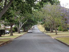
Rangeville is a suburb of Toowoomba, Queensland, Australia, located 5 kilometres (3 mi) south-east of the city centre. At the 2011 Australian Census the suburb recorded a population of 8,217.
Contents
Map of Rangeville QLD 4350, Australia
Geography
The suburb's eastern boundary is home to four reserves: Picnic Point Park (with several lookouts, a restaurant and a bar); Mount Tabletop, accessible only by a walking track from Table Top Drive; McKnight Park, and J. E. Duggan Park, named for former Labor Opposition leader Jack Duggan who represented the local area for over 30 years. The western boundary along East Creek is home to the Toowoomba Bicentennial Waterbird Habitat.
At Pincic Point a 150-foot flagpole was erected as part of the Q150 celebrations.
History
As closer settlement moved further along the range from Toowoomba, the suburb appears to have been named Rangeville to distinguish it from The Range, which was the general term for the area along the Range.
Heritage listings
Rangeville has a number of heritage-listed sites, including:
Education
Rangeville contains two schools: Rangeville State School (1909) and St. Joseph's College (Catholic, 1956).
