
Location Tasman Bay Population 0 | Length 8 km (5 mi) Area 15 km² | |
 | ||
Rabbit Island is the name of several different islands off the New Zealand coast.
Contents
- Map of Rabbit Island 7081 New Zealand
- Moturoa Rabbit Island
- Others islands with the same name
- References
Map of Rabbit Island, 7081, New Zealand
Moturoa / Rabbit Island
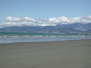
The largest and best-known, Moturoa / Rabbit Island lies across the southernmost part of Tasman Bay, at the top of New Zealand's South Island. The long narrow island runs east-west for 8 kilometres (5 mi), and covers 15 km2 (5.8 sq mi).
It lies opposite the mouth of the Waimea River, 7 kilometres (4.3 mi) to the west of Richmond and was formed about 7000 years ago as several barrier islands accumulated near the mouth of the Waimea River. There is evidence of Maori occupation for over 800 years. The original vegetation comprised tussock, manuka scrub and totara forest further inland.
The Rabbit Island Recreational Reserve contains three islands, Rabbit Island, Rough Island and Bird Island, and became a public reserve in 1908. Rabbit Island, with its long, safe swimming beach is a popular beach resort to the residents of Motueka, Wakefield, Brightwater, Richmond, Mapua, Stoke and Nelson itself.
A medium-sized causeway spans a tidal area and joins the mainland to Rabbit Island itself. There is a large grassed area after this bridge and a Fire Hazard sign ("Keep it Green"). Large areas of the relatively flat islands are covered in pine plantation forest. The beach proper contains vast and mountainous sand dunes topped with masses of cone-bearing pines, with exposed roots, extending for long distances along the island.
The Tasman's Great Taste Trail, a cycleway running from Richmond to Motueka, runs through Rabbit Island. There is also a newly established equestrian area. The reserve area is closed to the public from dusk to 5am.
In August 2014, the name of the island was officially altered to Moturoa / Rabbit Island.
Others islands with the same name
The other Rabbit Islands are smaller than 1 km2 (0.386 sq mi) or 100 ha (250 acres). They are located (north to south):
- inside Whangarei Harbour, Northland Region 35.7888°S 174.3475°E / -35.7888; 174.3475
- just west of Great Barrier Island, Hauraki Gulf 36.1477°S 175.3140°E / -36.1477; 175.3140
- to the west of Kawau Island, north of Auckland 36.4146°S 174.7932°E / -36.4146; 174.7932
- off the east coast of the Coromandel Peninsula, in Opito Bay 36.7137°S 175.8177°E / -36.7137; 175.8177
- off the east coast of the Coromandel Peninsula, near Slipper Island 37.0713°S 175.9272°E / -37.0713; 175.9272
- officially known as Motuotau Island, north of Tauranga, off the beach east of Mount Maunganui 37.6311°S 176.1940°E / -37.6311; 176.1940
- Rabbit Island, a six-hectare islet close to Pitt Island in the Chatham Islands 44.2400°S 176.2817°E / -44.2400; 176.2817
- inside the entrance to Blueskin Bay, north of Dunedin 45.7311°S 170.5907°E / -45.7311; 170.5907
- south of Riverton, in Foveaux Strait
- near the centre of Bluff Harbour, Southland Region 46.5680°S 168.3305°E / -46.5680; 168.3305