
- elevation 0 ft (0 m) | Length 6 km | |
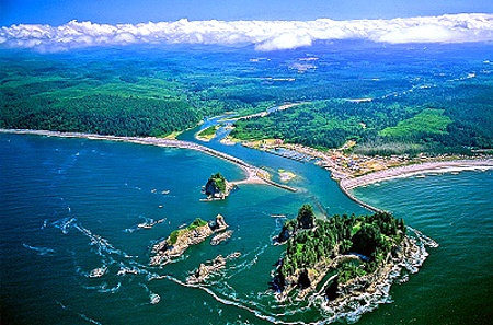 | ||
The Quillayute River (also spelled Quileute River) is a river situated on the Olympic Peninsula in Washington. It empties to the Pacific Ocean at La Push, Washington. The Quillayute River is formed by the confluence of the Bogachiel River, Calawah and the Sol Duc River. The Dickey River joins the Quillayute just above the river's mouth on the Pacific Ocean.
Map of Quillayute River, Washington, USA
Although the Quillayute is one of the main rivers on the Olympic Peninsula and has a large drainage area, due to an unusual naming arrangement it is officially very short, being only about 4 miles (6.4 km) long. At the confluence of the Sol Duc and Bogachiel rivers the use of the Quillayute name ends, although the river continues far into the interior.
The Quillayute River is the current, traditional and ancestral center of the territory of the Quileute Native Tribe, which before European settlement occupied the entire drainage basin (plus that of the Hoh River). Presently the natives live at the town of La Push on their small treaty reservation which adjoins the south shore of the river at the mouth.
The final 2 to 3 miles (3.2 to 4.8 km) at the mouth of the Quillayute pass through the narrow coastal strip of the Olympic National Park. Park roads lead to the Mora and Rialto Beach recreation area on the north side of the Quillayute. There are camping and picnicing facilities, public parking, and trailhead access to the coastal wilderness strip north of the river.