
OS grid reference TL565814 Dialling code 01353 | Sovereign state United Kingdom Postcode district CB7 | |
 | ||
Queen Adelaide is a hamlet on the River Great Ouse in the Fens about 1 1⁄2 miles (2.4 km) northeast of Ely, Cambridgeshire (where the population is included), England.
Map of Queen Adelaide, Ely, UK
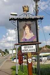
The hamlet is named after a pub, which in turn was named after Queen Adelaide, consort of King William IV. The hamlet did not exist until the 19th century, when the railways reached Ely and the pub was built.
The B1382 road is Queen Adelaide's main street. South of the hamlet is a junction of three railways: the Fen, Breckland and Ely to Peterborough railway lines. Each of the three lines crosses the hamlet's main street with a separate level crossing. West of the hamlet there is also a loop line, the Adelaide Loop, that the B3182 crosses on a bridge.
Queen Adelaide is in the Church of England parish of Ely Cathedral, which is 2 miles (3 km) away by road, so in 1883 a chapel of ease was built in the hamlet. It was dedicated to St Etheldreda, who was a 7th-century East Anglian princess and Abbess of Ely. More recently the chapel has been deconsecrated and converted into a private house.