
Local time Monday 5:17 PM | ||
 | ||
Weather 32°C, Wind S at 27 km/h, 24% Humidity | ||
Qaryat al-Saiḥ (literally, village of the flowing) in Wadi Maḥram (23°01'N; 58°00'E, 712 m altitude) is an archaeological site in Samaʾīl Wilayat Sharqiyah, in Central Oman. This fortified village was inhabited in the Samad Late Iron Age and during Islamic times.
Overview
Perhaps in the 1990s Gerd Weisgerber first noticed this Samad Late Iron Age settlement who gave no specifics about it, neither its exact location, size or plan were known. Even the dating could be questioned since no information was put forth. Three antiquities signs stand to the E and NE of the site near the road.
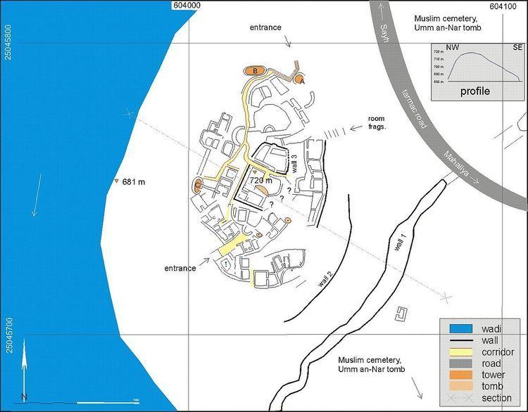
The preservation condition and our recording methods condition the appearance of the resulting sketch. More time with a more sophisticated equipment (aerial imagery, tachymeter etc.) will improve the drawing. The main structure measures some 50 x 90 m, i.e. is c. 4000 m2 in surface area. It lies as much as high as 50 m above the surrounding wadi. 100 m to the SW lies a garden (Fig. 1), which supported the population in antiquity. The site is built adjacent to a low area. The west and south flanks are protected by the wadi and its steep slope (see the section in Fig. 1). Walls range up to 2 m in height. Upslope, the houses have walls up to 80 cm in thickness. At key points there are irregularly shaped towers which a thicker wall diameter. The gate construction is not preserved. It leads the visitor into the village via corridors. In the south-east the irregular wall 2 is preserved up to 1 m in height. Further uphill, the heavier wall 3 encloses the core. In its midst les a ruined Umm an-Nar tomb of some 7 m diameter. A large wall (no. 1) thwarts the site from the mountain to the north-east to the wadi in the south-west. This seems to be of recent date. The building of the road and the water in the wadi transsect this wall. It ranges from 60 cm to 2 m in height.
Amid the rubble, rooms and walls are challenging to reconstruct. The preservation is variable. Entrances are difficult to recognise. Of the 11 Google Earth images the one with the best definition is from 24.12.2011. The white patches especially on the southern and south-eastern perimeter of wall 3 visible in the satellite image are rooms often of the casemate fortification. Walls are preserved maximally to 2 m. Although the rooms appear to be ovoid, in fact, they are rectangular. This results from the collapse of the superstructure into the corners. Characteristic are casemate walls. This seems to be typical of the Samad LIA defensive architecture, as opposed to that of the preceding period.
The sketch shows fortification walls maximally 1.0 m in thickness and corridors inside the fortification. There were many changes during the course of the building visible in the context. The building material was mainly unmortared stone. Abundant disintegrated mud brick and perhaps saruj wall fragments lie amid the stones. Samad LIA (50%) and Muslim Period glazed sgrafiato pottery litter the site. South-west of the site (603830 m E, 2545442 m N, alt. 733 m) a 30x30 m area shows small terrace-like structures which may be LIA graves, about 450 m from the site.