
District Chittoor Time zone IST (UTC+5:30) Area 34.81 km² Local time Thursday 10:42 PM | Mandal Puttur PIN 517583 Population 54,092 (2011) | |
 | ||
Weather 28°C, Wind SE at 6 km/h, 81% Humidity Neighborhoods Aretamma Colony, Old Wewing Colony, GatePuttur, Ramarao Colony | ||
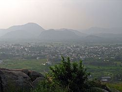
Puttur is a census town in Chittoor district of the Indian state of Andhra Pradesh. It is the mandal headquarters of Puttur mandal in Chittoor revenue division.
Contents
Map of Puttur, Andhra Pradesh 517583
Geography
Puttur is located at 13.43°N 79.55°E / 13.43; 79.55. It has an average elevation of 144 metres (472 feet).
Education
The primary and secondary school education is imparted by government, aided and private schools, under the School Education Department of the state. The medium of instruction followed by different schools are English, Telugu.
References
Puttur, Andhra Pradesh Wikipedia(Text) CC BY-SA