
Population (2008) 289 Local time Tuesday 9:32 PM | Intercommunality Savinois–Serre Ponçon Area 13.2 km² | |
 | ||
Weather 12°C, Wind N at 3 km/h, 60% Humidity | ||
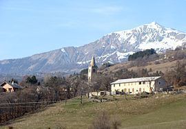
Prunières is a commune in the Hautes Alpes department in southeastern France.
Contents
Map of 05230 Pruni%C3%A8res, France
Geography
It is close to Chorges which is the closest commerce town. Bigger towns near Prunières include Gap (25 km) to the west or Embrun (15 km) to the east. Prunières is located close to the Lac de Serre-Ponçon, one of the largest artificial lakes in Western Europe, and surrounded by gorgeous mountains.
Tourism
The main activity in the winter is skiing, while one can enjoy mountain climbing/hiking and water activities on the Lac de Serre-Ponçon.
References
Prunières, Hautes-Alpes Wikipedia(Text) CC BY-SA