
Length 1.8 km Major cities Dunedin | Location Dunedin, New Zealand Postal code 9016 | |
 | ||
North end Octagon, central Dunedin South end King Edward Street/Ardmore Drive, Kensington | ||
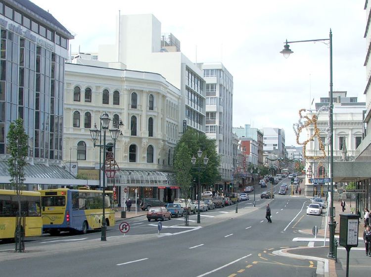
Princes Street (often misspelt as "Princess Street") is a major street in Dunedin, the second largest city in the South Island of New Zealand. It runs south-southwest for two kilometres from The Octagon in the city centre to the Oval sports ground, close to the city's Southern Cemetery. North of The Octagon, George Street continues the line of Princes Street north-northeast for two and a half kilometres. Princes Street is straight and undulates as it skirts the edge of the City Rise to its northwest. The part of the street immediately below The Octagon is the steepest section, as the road traverses an old cutting through Bell Hill.
Contents
- Map of Princes St Dunedin 9016 New Zealand
- History
- The Top 100
- The Exchange
- Below the Exchange
- Transport links
- Heritage New Zealand listed buildings
- References
Map of Princes St, Dunedin, 9016, New Zealand
Princes Street was developed during Dunedin's 1860s boom from the Central Otago gold rush, and consequently is one of New Zealand's most historic streets, with about 70 buildings in close proximity listed on the New Zealand Historic Places Trust Register. Originally the site of the city's wharf, a substantial area of land to the east of the street was formerly part of Otago Harbour, much of it reclaimed via rock removed during the lowering of Bell Hill which separated Princes Street from northern Dunedin in the early years of settlement. In the years following the gold rush, Princes Street was the heart of Dunedin's central business district, but much of the city's main retail area has now shifted north to George Street.
History
In the early years of Dunedin's settlement, much of the city's growth was on two areas of reasonably flat land close to the harbour, separated by the large Bell Hill and an area of low swampy land. The northern of these two flat areas surrounded the floodplain of the Water of Leith, a small river that runs through Dunedin. As the city grew the swamp was drained to become the new city's centre, and the hill was lowered by excavation to allow access between the two areas of settlement. A street grid was set up with the main road split in two by the city centre (now The Octagon) - Princes Street to the south and George Street to the north. As with many of the city's other place names, both these names and that of the Water of Leith reflect the names of places in Edinburgh.
In the settlement's early days, Bell Hill proved a major obstacle to travel south of the city centre, and major excavation work was carried out to provide access to the south. A cutting was made in the hill in 1858, and during the 1860s the hill was lowered by some 14 metres (46 ft). The cutting allowed for the passage of transport between the two parts of the town. The southern flank of the hill was also completely removed (that area now being occupied by Queen's Gardens). The stone removed from the hill was used as construction material for many of the city's first permanent buildings, and also as fill to reclaim the northern end of the Southern Endowment along the edge of the harbour. This reclamation work added a considerable area to the central city; the original docks, close to the Exchange area of Princes Street, are now several hundred metres inland.
The area of Princes Street between the Exchange and Market Reserve was a frequent source of dispute in the early years of European settlement. This area, at that time on the foreshore of Otago Harbour was a traditional landing site for Māori waka. Captain Cargill, the founder of the new city, wished to follow the British practice of keeping the foreshore as public land. As the town spread, the area around the landing site became populated by settlers, and visiting Maori relied on the coastal strip as a place to set up their encampments. The southern Commissioner for Crown Lands, Walter Mantell noted the problem and proposed to his superiors in Wellington that a site be found at which the Māori could erect permanent structures, naming the Princes Street foreshore as the preferred site. Mantell and Cargill, who had been bitter political opponents for the control of the early settlement, quickly found themselves at loggerheads over the proposal, and disputes over the ownership and allocation of the land dragged on for over two decades, finally being settled in the courts in 1877.
In the years following the Central Otago Gold Rush of the 1860s Dunedin grew rapidly, with much of the growth being centred on Princes Street. In the city's early years this road was notorious for its unformed rough nature, a consequence of the work on Bell Hill, and led to Dunedin's early nickname of "Mud-edin". The prosperity brought by the gold rush led to a boom in construction, and within a handful of years, the area around lower Princes Street became the most prosperous in the country. Many of the prominent grand buildings of this part of Dunedin date from this period, and numerous structures in the area have New Zealand Historic Places Trust classification as a result.
There is a considerable photographic record of early Princes Street, largely thanks to the presence in the street of the studios of the Burton Brothers, pioneering New Zealand photographers. Many of their images, and those of other early Dunedin photographers, were collated and published in a series of books by photographic historian Hardwicke Knight, one of which — a collection of photographic works by Daniel Louis Mundy — was entitled Princes Street by gaslight (1977).
Several notable companies have either been founded or had their headquarters in Princes Street. Notable among these were The Drapery and General Importing Company of New Zealand, later simply known as The D.I.C., Hallenstein's, and H.E. Shacklock. The first New Zealand headquarters of Briscoes were also located on Princes Street.
The "Top 100"
From the Octagon, Princes Street initially rises as it passes through a commercial district formerly commonly known as the Top 100, crossing the outer Octagon of Moray Place before descending through the original cutting of Bell Hill towards the Exchange. The Top 100 theoretically takes its name from the 100 retail businesses which line Princes Street from the Octagon to the Exchange, although the actual number of businesses is not one hundred. This part of the city is sometimes seen as the creative heart of Dunedin, with numerous art galleries, video production companies, and the city's professional theatre (the Fortune Theatre) all being based in the area from Moray Place to Rattray Street.
Some parts of the Bell Hill cutting are still visible from Princes Street, though the most obvious escarpment of the hill is found between Moray Place and Queen's Gardens, close to First Church. From Princes Street, the most notable part of the cutting is at Dowling Street, 300 metres south of the Octagon. Dowling Street narrows significantly above this intersection. The Dowling Street Steps, a 1926 structure listed by the New Zealand Historic Places Trust, rise from close to the Princes Street-Dowling Street intersection, ascending a cliff that was formed as a result of the original work on Bell Hill.
The Exchange
The Exchange, on Princes Street 400 metres south of The Octagon, was the original financial heart of the city, but the CBD has drifted north to its current location on George Street. Princes Street still contains many of the city's older and more stately business properties, particularly in the few blocks from The Exchange south. This area is also the lowest part of the street, as it descends from the remains of Bell Hill. This area, now several hundred metres inland from the edge of the Otago Harbour, was the site of the original landing place of settlers from the two ships which brought the Otago Association's settlers to Dunedin. The two ships, the John Wickliffe and the Philip Laing, arrived in early 1848. As they could not negotiate the harbour, they set anchor at the Otago Heads. Settlers from the ships travelled by smaller rowing boat from there to Dunedin. Massive reclamation of the area led to the creation of a wide strip of land, since occupied by commercial premises, warehousing, and the main rail line. The original nature of the site is reflected in the names of Jetty Street and Water Street, both of which cross Princes Street close to the Exchange. This part of Princes Street was at one point the location of a bridge across a small stream, the Toitu Stream, now diverted underground. A spring which fed the stream is still used as the source of water for Speight's Brewery, which is located 200 metres to the northwest on Rattray Street.
The former Exchange Building, from which The Exchange takes its name, was an impressive structure, designed by William Mason as a Post Office and later occupied by the University of Otago and the Otago Museum. Next to this was the 1863 Customhouse building, and outside the two was an open space known as Customhouse Square. The Exchange building was pulled down in 1969, and it was largely the destruction of this building that led to changes in attitudes by Dunedinites regarding the change of their cityscape. Since this time, changes to the city's old buildings have been met with vociferous protests. The Customhouse building is also long since gone. Today, the site of the buildings is the location of Dunedin's biggest office block, John Wickliffe House, and the nearby John Wickliffe Plaza. Both are named for the John Wickliffe, the first of the two ships which brought the Otago Association's settlers to Dunedin (a nearby building, Philip Laing House, is named for the other of these two ships). Despite this, the area is the site of several prominent Victorian buildings, notably former bank buildings at the northern end of the area. Other imposing buildings in the area include the Chief Post Office building, the proposed site of a hotel, and - one block to the east - Consultancy House, a seven-storey 1908 building regarded (by dint of its construction methods) as Dunedin's first skyscraper. John Wickliffe Plaza is also the site of one of Dunedin's more notable public monuments, dedicated to city founder Captain William Cargill. This monument, designed by Charles Robert Swyer and built in 1863-4, was originally sited in the Octagon, but was moved to the Exchange in 1872.
The Exchange was at one time a complex intersection with two busy streets, Rattray Street and High Street. These lead from State Highway 1 at Queen's Gardens (an open park containing the city's main war memorial, Dunedin Cenotaph, close to which lies the Otago Settlers' Museum and the Dunedin Chinese Garden) 200 metres to the east of Princes Street, to the older hill suburbs to the west. Though these streets originally both crossed Princes Street, civic planning has reduced High Street at the intersection to a minor road, and John Wickliffe Plaza now covers part of the original intersection. Apart from the Cargill Monument, the Plaza contains several other items of public sculpture, notably a series of three small brass penguins called "We are not alone", sculpted by Parry Jones and unveiled in 1999. A Historic Places Trust blue plaque at the foot of the Cargill Monument marks the location of the first Salvation Army meeting in New Zealand, held at the site in April 1883.
Below the Exchange
The lower Exchange and area immediately to the south of it contains some other notable buildings, including several of Dunedin's more notable former and current public houses. Among these are Wain's Hotel, the Provincial Hotel (at the foot of Stafford Street), the Empire Tavern, and the former Prince of Wales Hotel. Wain's Hotel, immediately opposite the former Post Office building, is an imposing Italianate structure built in 1878 from designs by Mason and Wales. The Empire Tavern also has a long history, and claims to be Dunedin's oldest pub, having been continuously licensed since 1858. Its recent past is closely tied with the Dunedin Sound music scene of the 1980s, of which it was a principal venue. Prior to its gutting by fire in the 1980s, the Prince of Wales Hotel, a block further down Princes Street, was noted for an unusual gimmick, in that the upstairs restaurant facilities were extensively themed on old railway carriages, and included in their decor several original vintage pieces of rolling stock. The Prince of Wales was later (1992–2010) the location of one of the city's top restaurants, Bell Pepper Blues.
Lower Princes Street rises slightly from the Exchange before dropping down, becoming flat for the final kilometre of its length. Here, there is a mix of commercial, wholesale, and light industrial properties, with only occasional retail shops. The street itself widens from thee crest below the Exchange, becoming a dual carriageway from this point south to the major junction at the southern end of the Oval. Several notable buildings are still found in the lower Princes Street area, among them the former H.E. Shacklock building and the Crown Roller Mills Building; the latter in particular is a notable landmark.
The Crown Roller Mills building is not in Princes Street itself, but rather lies at the foot of Manor Place, close to its intersection with Princes Street. It stands at the edge of a small area of parkland called the Market Reserve, at the opposite edge of which is the city's main bus depot. This area was swampland when the first European settlers arrived in Dunedin, but was reclaimed and did host a regular market for a few years from the 1870s. The market was not well-supported, however, and eventually folded. The bus depot is located on the site of the city's 1902 Tram workshops. The Market Reserve also contains a children's playground and, at the edge closes to the Crown Roller Mills Building, a small monument dedicated to Otago workers who have lost their lives while at work. This simple bluestone memorial was erected in 2003 by the New Zealand Council of Trade Unions on a site donated by the Dunedin City Council.
At the bottom end of Princes Street is the former Dunedin Metropolitan Club building, now home to Natural History New Zealand, one of the country's leading television production companies. Opposite this lies a large recreation reserve, which — despite its roughly triangular shape — is called the Oval, or more correctly, Kensington Oval. Kensington Oval contains mainly cricket and association football pitches, and also caters for rugby, hockey, and softball. The Oval also contains one of the city's main war memorials, dedicated to the fallen of the Boer War campaign. This lies close to the Oval's northernmost point. Close to the Oval are two major road junctions. At the north end, a link road connects Princes Street with the city's one-way street system (part of State Highway 1) and with Anderson's Bay Road, a major arterial route to South Dunedin and Otago Peninsula. The part of Princes Street close to the Oval, as well as several other nearby streets, is used annually as part of the Dunedin Street Circuit, a temporary inner city motor-racing circuit used during the week-long Southern Festival of Speed.
At the southern end of the Oval is a further junction, with Princes Street terminating in a link road to South Dunedin's main street, King Edward Street, and a further road skirting the edge of a hilly spur to join South Road at the northern end of the suburb of Caversham. This latter road passes Dunedin's Southern Cemetery, the oldest and arguably most historic of the city's main cemeteries. The Southern Cemetery's earliest graves are from 1858, and it contains the remains of many of the city's founding fathers, including Captain William Cargill, Thomas Burns, and Johnny Jones. The cemetery is notable for its large Chinese and Jewish sections.
Transport links
The top section of Princes Street, from the Octagon to the Exchange, has long been the hub of Dunedin's public transport system. Buses from the north of the city largely pass along George Street and into the Octagon, those from the south pass into the southern end of Princes Street, and those from the hill suburbs arrive at the Octagon via Stuart Street or at the Exchange via High and Rattray Streets. Almost all of these use upper Princes Street between the Exchange and the Octagon as part of their route.
In the city's early years trams followed many of these same routes. Until the demise of the system in the 1950s, this area was also at the heart of the Dunedin cable tramway system, with the longer lines running up the slopes of City Rise via High, Rattray, or Stuart Streets.
Heritage New Zealand listed buildings
Few, if any, streets in New Zealand contain as many New Zealand Historic Places Trust Category I or Category II protected buildings as Princes Street. These buildings include the following:
The Cargill Monument at John Wickliffe Plaza is also listed (Category I), as are numerous buildings and structures which lie close to the intersection of side roads with Princes Street (e.g., the Category I Crown Roller Mills Building in Manor Place and the Category II Dowling Street Steps).