
Population 249 (2006 census) Local time Monday 2:26 AM | Postcode(s) 2257 Postal code 2257 Parish Kincumber | |
 | ||
Location 9 km (6 mi) SSE of Woy Woy Weather 20°C, Wind NW at 5 km/h, 92% Humidity | ||
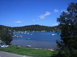
Pretty Beach is a south-eastern suburb of the Central Coast region of New South Wales, Australia on the Bouddi Peninsula. It is part of the Central Coast Council local government area.
Map of Pretty Beach NSW 2257, Australia
The beach itself does not face the sea directly but is part of Brisbane Water, making it a safe place for both children and the mooring of boats. Approximately 200 people live in the immediate area. Pretty Beach is surrounded by the Bouddi National Park. The main institution in the area is the Pretty Beach Public school, established in 1928, which services the greater Bouddi Peninsula community. The school had a major overhaul between 2007 and 2009 and now is entirely new. In 2010 a new community pre-school was opened immediately behind the school.
In October 2006 a 'revamped' boat ramp with floating pontoon was opened to the public that allows small and mid-sized trailer-launched boats to access Brisbane Water and beyond.