
Founded 1843 Congressional district 1st Area 1,518 km² | Population 18,601 (2013) | |
 | ||
Website www.poweshiekcounty.org Points of interest Grinnell Historical Museum, Louis Sullivan Jewel Bo, Arbor Lake Park | ||
Poweshiek county iowa
Poweshiek County is a county located in southeastern part of the U.S. state of Iowa. As of the 2010 census, the population was 18,914. The county seat is Montezuma. The county is named for the Indian chief of the Fox tribe who signed the treaty ending the Black Hawk War. It is located along Interstate 80, between Des Moines and Iowa City. The largest town in Poweshiek County is Grinnell.
Contents
- Poweshiek county iowa
- Map of Poweshiek County IA USA
- History
- Government and Infrastructure
- Healthcare
- Geography
- Major highways
- Adjacent counties
- 2010 census
- 2000 census
- Education
- Census designated places
- Other communities
- Population ranking
- References
Map of Poweshiek County, IA, USA
History
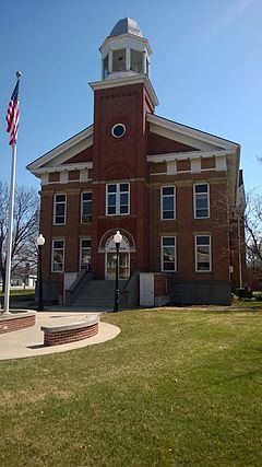
Poweshiek County was formed in 1843. It was named for the chief of the Fox Indians. The Poweshiek County Courthouse, completed in 1859, is listed on the National Register of Historic Places.
Government and Infrastructure
County business is overseen by three elected county supervisors. The county website provides names and contact information for the current supervisors: http://poweshiekcounty.org/supervisors/
Healthcare
Poweshiek County is served by Grinnell Regional Medical Center, an acute care hospital licensed for 81 beds. GRMC was established in 1967 after the merger of two hospitals.
Geography
According to the U.S. Census Bureau, the county has a total area of 586 square miles (1,520 km2), of which 585 square miles (1,520 km2) is land and 1.1 square miles (2.8 km2) (0.2%) is water. It is drained by the north fork of Skunk River, which crosses the southwest corner, and by English River and other streams.
Major highways
Adjacent counties
2010 census
The 2010 census recorded a population of 18,914 in the county, with a population density of 32.3300/sq mi (12.4827/km2). There were 8,949 housing units, of which 7,555 were occupied.
2000 census
As of the census of 2000, there were 18,815 people, 7,398 households, and 4,882 families residing in the county. The population density was 32 people per square mile (12/km²). There were 8,556 housing units at an average density of 15 per square mile (6/km²). The racial makeup of the county was 96.74% White, 0.55% Black or African American, 0.23% Native American, 1.07% Asian, 0.05% Pacific Islander, 0.49% from other races, and 0.87% from two or more races. 1.20% of the population were Hispanic or Latino of any race.
There were 7,398 households out of which 29.0% had children under the age of 18 living with them, 55.8% were married couples living together, 7.4% had a female householder with no husband present, and 34.0% were non-families. 29.2% of all households were made up of individuals and 13.9% had someone living alone who was 65 years of age or older. The average household size was 2.35 and the average family size was 2.88.
In the county, the population was spread out with 22.7% under the age of 18, 12.8% from 18 to 24, 24.4% from 25 to 44, 22.5% from 45 to 64, and 17.6% who were 65 years of age or older. The median age was 38 years. For every 100 females there were 92.5 males. For every 100 females age 18 and over, there were 88.8 males.
The median income for a household in the county was $37,836, and the median income for a family was $46,599. Males had a median income of $32,781 versus $22,465 for females. The per capita income for the county was $18,629. About 6.2% of families and 9.8% of the population were below the poverty line, including 12.0% of those under age 18 and 5.9% of those age 65 or over.
Education
Poweshiek County is served by three community school districts:
Poweshiek County is also home to Grinnell College, a small liberal arts college founded in 1846 and located in Grinnell..
There is one private school in the county, Central Iowa Christian School, in Grinnell.
Census-designated places
Other communities
Population ranking
The population ranking of the following table is based on the 2010 census of Poweshiek County.
† county seat