
Population 2,211 (2006 census) Local time Friday 9:49 PM | Postcode(s) 7307 Postal code 7307 | |
 | ||
Location 254 km (158 mi) N of Hobart79 km (49 mi) NW of Launceston, Tasmania20 km (12 mi) E of Devonport Weather 17°C, Wind NE at 21 km/h, 69% Humidity | ||
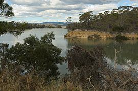
Port Sorell is a town on the north-west coast of Tasmania, Australia. It is on the waterway of the same name, just off Bass Strait, 20 km east of Devonport and close to Shearwater and Hawley Beach. It borders the Rubicon Estuary, which has been identified by BirdLife International as an Important Bird Area because of its importance for waders, especially pied oystercatchers.
Contents
Map of Port Sorell TAS 7307, Australia
History
The area was named Panatana by local Aborigines. The town was originally a fishing and sealing port named Burgess, however the name was officially changed to Port Sorell (after Governor Sorell) in 1822. The town could have been a lot larger than it is now, had it not been for bushfires, after which nearby Devonport grew to become a major port. At the 2006 census, Port Sorell had a population of 2,211. Today Port Sorell is one of many popular holiday spots along the north coast of Tasmania.
The first Port Sorell Post Office opened on 1 February 1845 and closed in 1863. The current office opened on 3 July 1944.