
 | ||
Pollock rip shoal top 6 facts
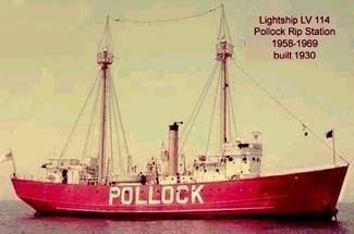
The channel at Pollock Rip Shoals is centered about three miles east of the southerly end of Monomoy Island in Chatham, Massachusetts. The channel, which runs east-west, is about eight miles south of the Chatham Lighthouse. Vessels passing around the Cape Cod coastline use the channel as a passage from the Atlantic Ocean to Nantucket Sound. The Pollock Rip Lightship marked the eastern approach to the channel from 1849 to 1969; it has since been replaced by a lighted buoy. The Stonehorse Lightship had previously identified the southeasterly end of the channel until October 1963, when it was removed by the U.S. Coast Guard and replaced with a small buoy. The channel extends six miles through the shoals and is 30 feet deep and 2,000 feet wide. It was completed in 1925.