
Location Caribbean Town Saint-François | Region Guadeloupe Adjacent body of water Caribbean Sea | |
 | ||
Adjacent bodies of water Atlantic Ocean, Caribbean Sea Similar Anse à la Gourde, Plage des Raisins Clairs, Zoo de Guadeloupe au Parc d, Carbet Falls, La Grande Soufrière | ||
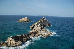
La Pointe des Châteaux (en: Castles headland) is a peninsula that extends into the Atlantic Ocean from the Eastern coast of the island of Grande-Terre, in Guadeloupe.
Contents
Map of Pointe des Ch%C3%A2teaux, Guadeloupe
Located 11 km East from Saint-François (the commune it is administratively attached to), it overlooks the island of La Désirade (a dependency of Guadeloupe), eructing only 8 km away into the Atlantic.
Made of distinctive rock formations and a large littoral strip, La Pointe des Châteaux hosts rare fauna and flora species, some of which being indigenous to the site.
A dramatic place of crashing waves and strong winds, La Pointe des Châteaux stands as a popular tourist destination, attracting an average of 500,000 visitors every year.
La Plage des Grandes Salines
Northwest to the Pointe des Châteaux's clifftop, lies the long but dangerous beach of les Grandes Salines : a popular spot for kite flying, thanks to its strong and steady trade winds. Sea conditions off the beach tending to be rough most of the time and the bottom dropping away relatively quickly, Grandes Salines is not suited for relaxed swimming, but remains sought-after for more extreme water sports and bay watchers.