
Airport type Military 4,860 1,472 | 04/24 4,860 1,472 Gravel | |
 | ||
Point Barrow Long Range Radar Site (LRR Site: A-17) is a United States Air Force radar site and military airstrip located 5 miles (8.0 km) southwest of Point Barrow, Alaska. It is not open for public use.
History
The United States military has maintained a presence at Barrow, Alaska's northernmost point, since World War II when the United States Army established a crude radar site at Point Barrow, although the chance of any Japanese attack to the area was remote. The Navy had taken over the existing civil airport and used its gravel runway to facilitate logistical support for naval assets in the Bering Straits and in and along the North Slope.
With the announcement of the Distant Early Warning Line in 1954, Point Barrow was designed as a main site, and a military airstrip, separate from the civil airport was constructed in 1955; being used for transport aircraft and passengers to build the DEW-line stations along the northern Alaskan coast.
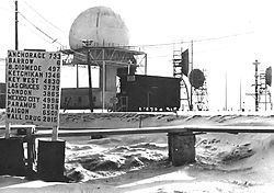
The Point Barrow station controlled seven manned stations, three of them being classified as "auxiliary" sites and four as "intermediate" stations. The auxiliary stations were similar to the main site at Point Barrow; the intermediate sites had less personnel at them. The stations were made up of an AN/FPS-19 search radar, a high power L-Band radar consisting of two identical radar sets feeding a dual (back to back) antenna with a range of about 160 nautical miles. The sites had one 25-man module building for personnel who supported the radar, and an airstrip, although the length and capacity varied greatly, making frequent risky landings necessary at some sites.
Each of the sites were staffed by civilian contract workers who had signed 18-month contracts, although they were visited by Air Force military personnel frequently.
With the signing of the North American Air Defence Modernization agreement at the "Shamrock Summit" between Prime Minister Mulroney and President Reagan in Quebec City on 18 March 1985, the DEW Line began its eventual upgrading and transition, becoming the North Warning System (NWS) of today. The intermediate sites were closed in 1963 due to the advancements in radar technology. Operational NWS sites have retained their former DEW Line designations. The BAR sites are under the jurisdiction of the Alaska NORAD Region ROCC at Elmendorf AFB.
In 1998, Pacific Air Forces initiated "Operation Clean Sweep", in which abandoned Cold War stations in Alaska were remediated and the land restored to its previous state. The site remediation of the radar and support station was carried out by the 611th Civil Engineering Squadron at Elmendorf, and remediation work was completed by 2005.
The airport remains open to support Air Force operations around Point Barrow and to support contractor access to the military radar site.