
Major islands North islet Area 1 ha | Highest elevation 1 m (3 ft) Elevation 1 m Adjacent body of water Solomon Sea | |
 | ||
Total islands 2 inhabited on Bentley Group | ||
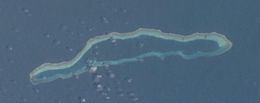
Pocklington Reef is a coral reef and a mostly submerged atoll in the far southeast of Papua New Guinea.
Map of Pocklington Reef
It is 162.4 km from the closest island, Loa Boloba, which is a tiny coral islet within the fringing reef near Cape Deliverance, the south east point of Rossel Island (Yela) in the Louisiade Archipelago, and belongs to Milne Bay province, Samarai-Murua District, Yaleyamba Rural Local Level Government Area.
Pocklington Reef sits on top of Pocklington Ridge, which extends north-east from Rossel Island. The reef is 32 km long and up to 4 km wide. Its longer axis is north-east-south-west. The rim of the reef encloses a deep lagoon. The northern rim reaches closer to the surface, and several above water rocks with heights between 0.9 and 3 metres high lie along its length. There is a small spit of sand about the size of a football field (less than one hectare) at the north-east end. There is a shipwreck at that location.
On 28 April 1962, Panamanian SS Dona Ourania grounded on Pocklington Reef.
Pocklington Reef Marine Park is a proposed marine protected area.