
Named for Pocahontas Time zone Central: UTC-6/-5 Area 1,500 km² County seat Pocahontas | Congressional district 4th Founded 1851 Population 7,154 (2013) Largest city Pocahontas | |
 | ||
Website www.pocahontas-county.com Cities Pocahontas, Laurens, Rolfe, Fonda, Plover, Havelock, Varina, Palmer Rivers Cedar Creek, Lake Creek, Beaver Creek, Pilot Creek | ||
Pocahontas County is a county located in Iowa, United States. As of the 2010 census, the population was 7,310. The county seat is Pocahontas. The county was formed in 1851.
Contents
- Map of Pocahontas County IA USA
- Geography
- Major highways
- Adjacent counties
- 2010 census
- 2000 census
- Unincorporated communities
- Population ranking
- References
Map of Pocahontas County, IA, USA
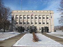
This county was named after the Native American princess from Jamestown, Virginia. A colossal statue of her stands in the city.
Geography
According to the U.S. Census Bureau, the county has a total area of 579 square miles (1,500 km2), of which 577 square miles (1,490 km2) is land and 1.4 square miles (3.6 km2) (0.2%) is water.
Major highways
Adjacent counties
2010 census
The 2010 census recorded a population of 7,310 in the county, with a population density of 12.654/sq mi (4.886/km2). There were 3,794 housing units, of which 3,233 were occupied.
2000 census
As of the census of 2000, there were 8,662 people, 3,617 households, and 2,430 families residing in the county. The population density was 15 people per square mile (6/km²). There were 3,988 housing units at an average density of 7 per square mile (3/km²). The racial makeup of the county was 98.49% White, 0.24% Black or African American, 0.17% Native American, 0.17% Asian, 0.01% Pacific Islander, 0.30% from other races, and 0.61% from two or more races. 0.89% of the population were Hispanic or Latino of any race.
There were 3,617 households out of which 29.50% had children under the age of 18 living with them, 58.30% were married couples living together, 5.90% had a female householder with no husband present, and 32.80% were non-families. 30.20% of all households were made up of individuals and 17.80% had someone living alone who was 65 years of age or older. The average household size was 2.35 and the average family size was 2.91.
In the county, the population was spread out with 25.40% under the age of 18, 5.30% from 18 to 24, 23.40% from 25 to 44, 24.10% from 45 to 64, and 21.70% who were 65 years of age or older. The median age was 42 years. For every 100 females there were 96.60 males. For every 100 females age 18 and over, there were 93.20 males.
The median income for a household in the county was $33,362, and the median income for a family was $40,568. Males had a median income of $27,929 versus $20,515 for females. The per capita income for the county was $17,006. About 6.60% of families and 9.10% of the population were below the poverty line, including 12.30% of those under age 18 and 6.50% of those age 65 or over.
Unincorporated communities
Population ranking
The population ranking of the following table is based on the 2010 census of Pocahontas County.
† county seat