
Isolation 2.7 km → Upsspitze Elevation 2,247 m | ||
 | ||
Prominence 2,247-2,045 m ↓ Hebertaljoch Similar Kohlbergspitze, Ammergau Alps, Daniel, Gartnerwand, Schellschlicht | ||
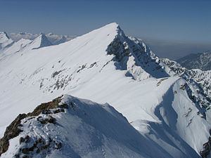
The Plattberg (also Blattberg) is a mountain in the southern chain of the Ammergau Alps. Its highest point is also called the Hochschrutte and reaches a height of 2,247 m (AA) The Plattberg lies north of Lähn and can be climbed from Lähn (railway station on the Außerfern Railway) or, on a more strenuous and trackless route from the lake of Plansee via the Wiesjoch col. The ascent of the mountain can be done as part of a ridge walk from or to the Daniel. The nearby peak of Großes fuitjöchl (2,196 m) is also a popular climb in winter for skiers or snowshoers.
Map of Plattberg, 6631, Austria
References
Plattberg Wikipedia(Text) CC BY-SA