
Country United States Width (crest) 1,475 feet (450 m) Total capacity 66 million m³ | Opening date 1951 Height 50 m | |
 | ||
Purpose Irrigation water storage Surface area 1.5 square miles (3.9 km) Similar Conejos Peak, Rocky Mountains, Heron Dam, Abiquiu Dam, El Vado Dam | ||
Platoro Dam (National ID # CO82911) is a dam in Conejos County, Colorado.
Map of Platoro Dam, Del Norte, CO 81132, USA
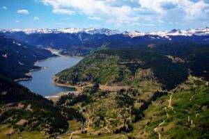
The earthen dam was constructed between 1949 and 1951 by the United States Bureau of Reclamation with a height of 165 feet (50 m), and 1,475 feet (450 m) long at its crest. It impounds the Conejos River, a tributary of the Rio Grande, for irrigation water storage as part of the larger San Luis Valley Project. The dam is owned by the Bureau, and operated by the local Conejos Water Conservancy.
The reservoir it creates, Platoro Reservoir, has a normal water surface of 1.5 square miles (3.9 km2), and a maximum capacity of 53,506 acre feet (65,999,000 m3). Recreation includes fishing, camping, boating and hunting, although use is light because of the remote, high mountain valley location and the short season.