
Elevation 389 m (1,276 ft) Area 2,048 km² | Time zone BRT/BRST (UTC-3/-2) | |
 | ||
Piranhas is a municipality in western Goiás state, Brazil. It is a large producer of milk and has a large herd of cattle.
Contents
- Map of Piranhas Boa Ventura Piranhas State of GoiC3A1s Brazil
- Location
- Demographic Information
- Economic Information
- Education and Health
- Tourism
- History
- References
Map of Piranhas - Boa Ventura, Piranhas - State of Goi%C3%A1s, Brazil
Location
Piranhas is located on the Piranhas River and is served by highways: BR-158, which connects Jataí to Aragarças; and GO-060, which connects Piranhas to Iporá.
The distance to the state capital, Goiânia, is 321 km. Highway connections are made by GO-060 / Trindade / Nazário / São Luís de Montes Belos / Israelândia / Iporá / Arenópolis.
Municipal boundaries are with:
Demographic Information
The population density was 5.44 inhab/km² in 2007. There were 8,872 urban dwellers and 2,267 rural dwellers. The population has declined by about 4,000 people since 1980.
Economic Information
The economy is based on mining, agriculture, cattle raising, services, public administration, and small transformation industries. In 2007 there were 19 small transformation industries and 128 commercial units. There were three banks: Banco do Brasil S.A. - BRADESCO S.A. - Banco Itaú S.A. There were two dairies: Maroca Indústria de Laticínios. - Lactosul Ind. de Laticínios Ltda (May 2006)
The main crops in 2006 were pineapple, rice, bananas, beans, manioc, soybeans, and corn. The cattle herd was large with 192,000 head in 2006.
Agricultural data 2006
Education and Health
In 2006 there were 12 schools, 103 classrooms, 194 teachers, and 3,602 students. In 2007 there were 3 hospitals with 87 beds.
Tourism
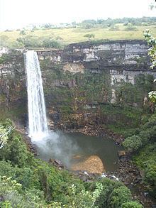
There is potential for eco-tourism with conditions for hiking, going down rapids, and other sports activities practiced near nature. The São Domingos river is ideal for canoeing, and descending on rafts or tire-tubes. Hikers can walk through virgin forests, which have unexplored caves.
History
Settlement began in 1948 when engineers and workers building the road between Caiapônia and Aragarças arrived in the region and set up camp on the banks of the Piranhas River. A settlement was created with the name of Piranhas, after the river. In 1952 it became a district of Caiapônia, receiving its municipal autonomy in 1953.