
River system Saginaw River Source Wheatland Township Country United States of America | Length 166 km Mouth Chippewa River | |
 | ||
Main source Wheatland Township, Mecosta County, Michigan River mouth Chippewa River
600 ft (180 m) Bridges Lincoln Road-Pine River Bridge | ||
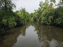
The Pine River is a 103-mile-long (166 km) river in the Lower Peninsula of the U.S. state of Michigan. The Pine River is a tributary of the Chippewa River and is thus part of the Saginaw River drainage basin.
Contents
Map of Pine River, Michigan, USA
The river rises in Wheatland Township in southeast Mecosta County at 43°35′09″N 85°08′34″W. It flows southeast into southwest Isabella County. It turns south through northeast Montcalm County and Gratiot County, where it turns to the northeast, continuing through the cities of Alma and St. Louis. It enters Midland County and joins the Chippewa River at 43°36′06″N 84°17′33″W approximately two miles before the Chippewa joins the Tittabawassee River on the west side of the city of Midland.
Tributaries and features
References
Pine River (Chippewa River) Wikipedia(Text) CC BY-SA