
Country United States FIPS code 29-57494 Elevation 371 m Population 1,268 (2013) Area code 417 | Time zone Central (CST) (UTC-6) GNIS feature ID 0724319 Zip code 65723 Local time Friday 8:51 AM | |
 | ||
Weather 6°C, Wind NW at 8 km/h, 98% Humidity Area 3.315 km² (3.289 km² Land / 3 ha Water) | ||
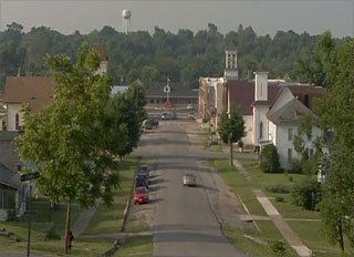
Pierce City, formerly Peirce City, is a city in Lawrence and Barry counties, Missouri, United States. The population was 1,292 at the 2010 census. In 2010, the town annexed down Route 97 into Barry County to a point just north of U.S. Route 60.
Contents
- Map of Pierce City MO 65723 USA
- Geography
- 2010 census
- 2000 census
- History
- Founding and spelling
- 1901 lynching incident
- May 2003 tornado
- References
Map of Pierce City, MO 65723, USA
Geography
Pierce City is located at 36°56′49″N 94°0′9″W (36.946996, -94.002430).
According to the United States Census Bureau, the city has a total area of 1.28 square miles (3.32 km2), of which 1.27 square miles (3.29 km2) is land and 0.01 square miles (0.03 km2) is water.
2010 census
As of the census of 2010, there were 1,292 people, 538 households, and 343 families residing in the city. The population density was 1,017.3 inhabitants per square mile (392.8/km2). There were 602 housing units at an average density of 474.0 per square mile (183.0/km2). The racial makeup of the city was 95.9% White, 0.8% Native American, 0.2% Asian, 1.8% from other races, and 1.3% from two or more races. Hispanic or Latino of any race were 4.6% of the population.
There were 538 households of which 33.3% had children under the age of 18 living with them, 45.0% were married couples living together, 13.8% had a female householder with no husband present, 5.0% had a male householder with no wife present, and 36.2% were non-families. 31.8% of all households were made up of individuals and 13.9% had someone living alone who was 65 years of age or older. The average household size was 2.39 and the average family size was 2.97.
The median age in the city was 37.4 years. 26% of residents were under the age of 18; 8.4% were between the ages of 18 and 24; 24% were from 25 to 44; 25.6% were from 45 to 64; and 16.2% were 65 years of age or older. The gender makeup of the city was 48.5% male and 51.5% female.
2000 census
As of the census of 2000, there were 1,385 people, 574 households, and 378 families residing in the city. The population density was 1,133.3 people per square mile (438.3/km²). There were 646 housing units at an average density of 528.6 per square mile (204.4/km²). The racial makeup of the city was 96.46% White, 0.22% African American, 1.08% Native American, 0.22% from other races, and 2.02% from two or more races. Hispanic or Latino of any race were 1.01% of the population.
There were 574 households out of which 33.3% had children under the age of 18 living with them, 48.4% were married couples living together, 12.5% had a female householder with no husband present, and 34.0% were non-families. 28.6% of all households were made up of individuals and 12.9% had someone living alone who was 65 years of age or older. The average household size was 2.41 and the average family size was 2.96.
In the city the population was spread out with 25.8% under the age of 18, 10.8% from 18 to 24, 28.2% from 25 to 44, 22.1% from 45 to 64, and 13.1% who were 65 years of age or older. The median age was 35 years. For every 100 females there were 94.0 males. For every 100 females age 18 and over, there were 84.7 males.
The median income for a household in the city was $24,186, and the median income for a family was $34,219. Males had a median income of $23,429 versus $17,857 for females. The per capita income for the city was $12,310. About 18.3% of families and 20.6% of the population were below the poverty line, including 20.8% of those under age 18 and 29.5% of those age 65 or over.
History
The Lawrence County Bank Building and Pierce City Fire Station, Courthouse and Jail are listed on the National Register of Historic Places.
Founding and spelling
Pierce City was laid out in 1870 as a stop on the Atlantic and Pacific Railroad. It was originally spelled Peirce City, named for Andrew Peirce, Jr. of Boston, president of the St. Louis–San Francisco Railway. The Pierce spelling was used erroneously by the United States Postal Service and adopted officially in the 1930s. A 1982 attempt to revert to Peirce was rejected by the United States Census Bureau.
1901 lynching incident
In 1901 a white lynch mob killed several African Americans in Pierce City and the rest of the black community was forced at gunpoint to leave the town by its white citizens. This incident prompted Mark Twain to write the essay The United States of Lyncherdom. A 2007 PBS documentary, Banished, featured the incident.[1]
May 2003 tornado
One of the most notable tornadoes of the May 2003 tornado outbreak sequence was the one that hit in Pierce City. According to reports, nearly all of the buildings in the town were damaged, destroyed, or liable to collapse. Published and repeatedly broadcast reports of "all" or "nearly all" of the town's buildings sustaining severe damage were false. Approximately 90 percent of the historic downtown business district and homes nearby were severely damaged and later torn down. A nearby National Guard Armory, also known as the town's storm shelter in which several dozen people had fled to, sustained heavy damage, killing one person, J. Dale Taunton. Raging Winds... However, outside the main path of the tornado, many Pierce City structures, including homes and the Harold Bell Wright Museum sustained little or no damage.
The Pierce City tornado was an F-3 on the Fujita scale.