
Country Vietnam Area 5,045.3 km2 Capital Tuy Hoa | Population 877,200 (2012) Region South Central Coast | |
 | ||
Phú Yên ( listen) is a coastal province in the South Central Coast of Vietnam. It is the easternmost province of Vietnam's mainland.
Contents
- Map of Ph Yn Province
- Ph t tv kh m ph ph y n exploring phu yen engsub
- History
- Geography
- Administrative divisions
- Demography
- Economy
- Agriculture forestry fishing
- Industry
- Transport
- Energy
- References
Map of Phú-Yên-Province
Ph t tv kh m ph ph y n exploring phu yen engsub
History
Prior to the 15th century, Phú Yên belonged to the Kingdom of Champa.
Geography
Phú Yên borders Bình Định Province to the north, Khánh Hòa Province to the south. Phú Yên is separated from these provinces by two passes: Cù Mông pass in the north and Cả pass in the south.
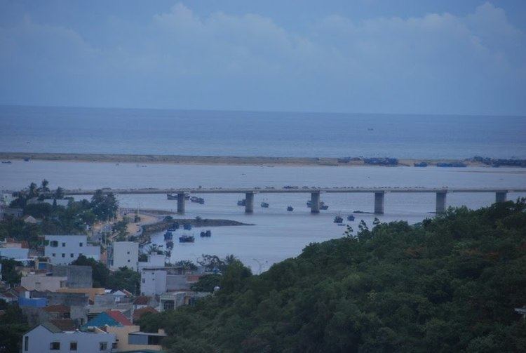
The province's topography consists of hilly regions in the west (70%) and the fertile plain of Tuy Hòa in the east. Lowlands also extend west along Đà Rằng River. The highest peaks are at 1592m on the border to Khánh Hòa Province in the south and at 1331m in the northwest (Đồng Xuân District). There are several hills near the coast, including Mo Cheo (Núi Mô Cheo, 814m) in Sông Cầu and Da Bia (Núi Đá Bia, 706m) near Dai Lanh in Đông Hòa District.
The main rivers that flow across Phú Yên are Đà Rằng River (the largest river in Central Vietnam), Ban Thach River and Ky Lo River. Song Hinh Lake, a large artificial lake, is located in the southwest of the province.
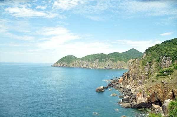
Phú Yên has various picturesque landscapes, such as the Ô Loan Lagoon, Sông Cầu coconut ranges, Đá Bia and Nhạn mountains, Rô Bay, Xep Beach and Long Thủy beach.
Administrative divisions
Phú Yên is subdivided into 9 district-level sub-divisions:
They are further subdivided into 8 commune-level towns (or townlets), 88 communes, and 16 wards.
Demography
As of 2007 Phú Yên has a population of 880,700. It has a relatively small urban population (178,600), making up 20% of the province's population. With 174 people per square kilometer, it is also one of the least densely populated province of the South Central Coast. Population density is relatively high (exceeding 500/km2) along the lower Đà Rằng River, but is lower than 50/km2 in much of the western part of the province. Average yearly population growth between 2000 and 2007 has been 1.3%, close to the regional average. Urban population growth has been faster with 2.2% per year on average.
The vast majority of the population is ethnic Kinh. There are also minorities of Cham, E De, and Ba Na people. Significant minorities of Cham live in Đồng Xuân District and Sơn Hòa District and E De people in Sông Hinh District and Sơn Hòa District. Much smaller communities of Ba Na people also live in these three districts.
Economy
With a GDP per capita of 8.43 million VND in 2007 and a relatively small industrial sector Phú Yên is one of the less developed province of the South Central Coast.
Phú Yên has had a trade deficit. In 2007, it exported goods worth 72.7 million US$ while importing goods worth 116.25 million, mainly fuel, raw materials, machinery, and medical goods.
Total employment was at 482,800 in 2007. The vast majority (361,400) are still employed in agriculture, forestry, and fishing. 45,600 people were employed in industry and construction and 75,800 in the service sector. Both industry and service have showed little employment growth between 2005 and 2007. Service employment has actually declined significantly since 2000.
Agriculture, forestry, fishing
The main agricultural regions of the province are the plains around Tuy Hòa and the lowlands along Đà Rằng River. In 2007 the rice harvest was 321,800t. It is the South Central Coast's largest producer of sugar-cane with a harvest of 1.051 million tonnes (6% of Vietnam's total harvest). Cultivation of cotton and tobacco is also significant, with 800t (5% of the national total) and 700t (2.2%) respectively. Other crops include peanuts, cashew nuts, pepper, and coffee.
Phú Yên has a relatively large fishing sector. Its gross output is the third largest in the South Central Coast after Khánh Hòa Province and Bình Định Province. Aquaculture, mostly shrimp farms, made up around one third of the fishing output, while using 2300ha.
Industry
Phú Yên is one of the less industrialized provinces of the South Central Coast. Its industrial production is mostly based on the processing of local primary products, such as fish, shrimp, cashew nuts, sugar. The province also produces mineral water, beer, garments, and cement. Industrial parks are located in the north of Tuy Hòa and Sông Cầu, near Quy Nhơn.
The province is zoning and developing a large economic zone, namely the Nam Phú Yên Economic Zone in the southern Đông Hòa District. Upon completion, it will become an oil-refining hub in Vietnam and potentially provide high profits for the province.
Transport
National Route 1A as well as the North–South Railway run through the province. Phú Yên's main railway station is Tuy Hòa Railway Station. Smaller railway stations are located in Đồng Xuân District and Tuy An District north of Tuy Hòa. National Road 25 connects Tuy Hòa to Chư Sê in Gia Lai Province, mostly along the Đà Rằng River.
Dong Tac Airport, a small domestic airport, is located south of Tuy Hòa.
The province has a port around 28 km south of Tuy Hòa, namely Vung Ro Port (cảng Vũng Rô).
Energy
A hydropower plant is located in Sông Hinh District in the southwest of Phú Yên. It is built on Hinh River, a major tributary of Đà Rằng River and created a lake of the same name (Sông Hinh Lake, meaning River Hinh Lake). Phú Yên produced 379.9 million kwh of electricity in 2007.