
Country India PIN 232329 Elevation 58 m Area code 05497 | Time zone IST (UTC+5:30) Telephone code 05497 Population 33,819 (2011) | |
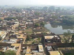 | ||
Phooli (Hindi: फुली),village is located between Dildarnagar and Zamania in Ghazipur district in the Indian state of Uttar Pradesh. The village is situated close to the Ganges river.
Map of Phooli, Uttar Pradesh
Phooli is a very old village, it is one of the oldest village in Ghazipur district. Phooli has a bus station on the main road route between Zamania and Bara. The people of the village are primarily Hindu and Muslim. The common languages used are Hindi and Bhojpuri, with Bhojpuri being the day-to-day language.
As of 2010 India census, Phooli had a population of 33,819. Males constitute 57% of the population and females 43%. Phooli has an average literacy rate of 53%, lower than the national average of 59.5%: male literacy is 69%, and female literacy is 48%. In Phooli, 20% of the population is under 6 years of age.
All kinds of primarily facilities like market, education, hospital, transpor, etc. are available here. Haulia chowk is the main market of Phooli. The major means of transport is road, which can be taken or hired from haulia chowk stand.The village has 2500 ration cards.
There are some private educational institutions and two government schools ( Prathmic Vidyalaya,SRI M.A.D.A.P.V. school. Shree Aditya Lal Janata Yoges High school.
Though the village has 53% average literacy, some qualified Doctors, Advocates, Engineers, Lectures, Teachers etc. belonging from here makes the village progressive.