
Time zone CET (UTC+1) Area code 53 | Municipality Petrovo Local time Wednesday 4:20 PM | |
 | ||
Weather 22°C, Wind NW at 6 km/h, 26% Humidity | ||
Petrovo (Serbian Cyrillic: Петрово) is a town and relatively young municipality located in northern Bosnia and Herzegovina, part of the Republika Srpska entity. The municipality was formed from parts of the pre-war municipalities of Gračanica and Lukavac (the other parts of the pre-war municipalities are now in the other Bosnian entity of Federation of Bosnia and Herzegovina).
Contents
- Map of Petrovo Bosnia and Herzegovina
- Geography
- History
- Town of Bosansko Petrovo Selo Petrovo itself
- Other villages
- 2006
- References
- Governance
- Municipality
- Culture
- Twin municipalities Sister municipalities
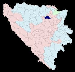
Map of Petrovo, Bosnia and Herzegovina
Geography
The municipality is close to Doboj just a halfway between Doboj and Tuzla. It is located on the mountain Ozren.
History
The municipality was formed by Bosnian Serb authorities during the war. Bosnian government never recognised this decision and officially municipality was created after the signing of the Dayton Agreement. Bosnian serb authorities also changed the name of the municipality to Petrovo from Bosansko Petrovo Selo. The municipality existed before, however, was dismantled in the 1960s. It belonged to Gračanica and Lukavac as well.
Town of Bosansko Petrovo Selo (Petrovo) itself
total: 2,919
Other villages
Kakmuž
total: 2,398
Karanovac
total: 1,178
Krtova
total: 1,121
Porječina
total: 819
Sočkovac
total: 1,112
2006
In 2006, the majority of inhabitants of municipality were ethnic Serbs.
References
Governance
Municipality
The following villages are constituents of Petrovo municipality:
Culture
The Saint Nikola monastery of the Serb Orthodox Church is in the Petrovo municipality.