
Existed: 1932 – present Constructed 1932 | Length 4,146 km | |
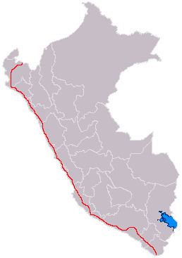 | ||
From: Aguas Verdes, Tumbes, Peru To: Santa Rosa Border Post, Tacna, Peru Major cities Tacna, Trujillo, Lima, Sullana, Chimbote, Arequipa, Chiclayo, Piura, Tumbes, Peru, Ica, Peru, Moquegua | ||
Peru Highway 1, most widely known as Carretera Panamericana, is the most important highway in Peru.
Map of 1ND, Chancay, Peru
This road is the Peruvian portion of the Pan-American Highway. It runs north-south through the whole length of the country and connects all major cities in the country's coastal area.
The northern terminus of the highway is located in Aguas Verdes (Tumbes Region) at the border with Ecuador. Starting in this point, the highway is known as Carretera Panamericana Norte ("North Pan-American Highway") until it reaches a point located in central Lima, the country's capital.
Going south from this point, the highway is called Carretera Panamericana Sur ("South Pan-American Highway"), until it reaches the southern terminus, located in the Santa Rosa Border Post, in the Tacna Region at the border with Chile.