
Founded 1919 Website pershingcounty.net Population 6,877 (2013) | Area 15,716 km² | |
 | ||
Rivers Sonoma Creek, Granite Creek, Little Cottonwood Creek Points of interest Black Rock Desert, Rye Patch Reservoir, Pershing County Marzen H, Tobin Range | ||
160 acres vacant land in pershing county nevada parcel 01205007
Pershing County is a county located in the U.S. state of Nevada. As of the 2010 census, the population was 6,753. Its county seat is Lovelock. The county was named after army general John J. Pershing (1860–1948). It was formed from Humboldt County in 1919, and the last county to be established in Nevada. The Black Rock Desert, location for the annual Burning Man festival, is partially located in the county.
Contents
- 160 acres vacant land in pershing county nevada parcel 01205007
- Map of Pershing County NV USA
- Visit pershing county nevada by ths visuals motion pictures
- Geography
- Adjacent counties
- National protected area
- 2000 census
- 2010 census
- City
- Census designated places
- Other unincorporated communities
- References
Map of Pershing County, NV, USA
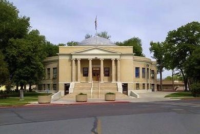
The county is listed as Nevada Historical Marker 17. The marker is located at the courthouse in Lovelock.
Visit pershing county nevada by ths visuals motion pictures
Geography
According to the U.S. Census Bureau, the county has a total area of 6,067 square miles (15,710 km2), of which 6,037 square miles (15,640 km2) is land and 31 square miles (80 km2) (0.5%) is water. The tallest and most topographically prominent mountain in Pershing County is Star Peak at 9,840 ft (3,000 m).
Adjacent counties
National protected area
2000 census
As of the census of 2000, there were 6,693 people, 1,962 households, and 1,383 families residing in the county. The population density was 1 person per square mile (0.4/km²). There were 2,389 housing units at an average density of 0 per square mile (0/km²). The racial makeup of the county was 77.69% White, 5.35% Black or African American, 3.42% Native American, 0.63% Asian, 0.22% Pacific Islander, 9.38% from other races, and 3.30% from two or more races. 19.33% of the population were Hispanic or Latino of any race.
There were 1,962 households out of which 38.40% had children under the age of 18 living with them, 57.20% were married couples living together, 7.30% had a female householder with no husband present, and 29.50% were non-families. 24.30% of all households were made up of individuals and 8.60% had someone living alone who was 65 years of age or older. The average household size was 2.69 and the average family size was 3.22.
In the county, the population was spread out with 25.70% under the age of 18, 8.50% from 18 to 24, 36.00% from 25 to 44, 22.10% from 45 to 64, and 7.80% who were 65 years of age or older. The median age was 34 years. For every 100 females there were 158.80 males. For every 100 females age 18 and over, there were 182.10 males.
The median income for a household in the county was $40,670, and the median income for a family was $46,268. Males had a median income of $34,417 versus $24,301 for females. The per capita income for the county was $16,589. About 10.20% of families and 11.40% of the population were below the poverty line, including 14.20% of those under age 18 and 5.60% of those age 65 or over.
2010 census
As of the 2010 United States Census, there were 6,753 people, 2,018 households, and 1,375 families residing in the county. The population density was 1.1 inhabitants per square mile (0.42/km2). There were 2,464 housing units at an average density of 0.4 per square mile (0.15/km2). The racial makeup of the county was 81.9% white, 3.7% black or African American, 3.2% American Indian, 1.3% Asian, 0.1% Pacific islander, 6.7% from other races, and 3.1% from two or more races. Those of Hispanic or Latino origin made up 22.3% of the population. In terms of ancestry, 19.5% were German, 16.8% were Irish, 13.8% were English, 5.1% were Italian, and 4.4% were American.
Of the 2,018 households, 31.6% had children under the age of 18 living with them, 51.9% were married couples living together, 9.1% had a female householder with no husband present, 31.9% were non-families, and 26.6% of all households were made up of individuals. The average household size was 2.51 and the average family size was 3.02. The median age was 41.0 years.
The median income for a household in the county was $56,491 and the median income for a family was $61,410. Males had a median income of $51,333 versus $28,871 for females. The per capita income for the county was $17,519. About 10.2% of families and 13.7% of the population were below the poverty line, including 23.0% of those under age 18 and 2.7% of those age 65 or over.
City
Census-designated places
Other unincorporated communities
Many of the following places are considered ghost towns.