
- elevation 650 m (2,133 ft) Length 165 km Country Peru | - elevation 400 m (1,312 ft) Mouth Tambo River | |
 | ||
- location confluence of the Chanchamayu and Pawkartampu Rivers, Peru - location confluence with Ene River, Peru | ||
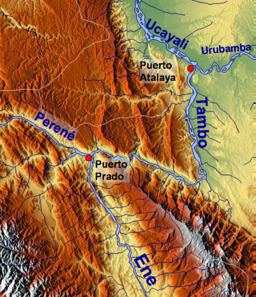
The Perené River (Spanish: Río Perené) is a Peruvian river on the eastern slopes of the South American Andes.
Map of R%C3%ADo Peren%C3%A9, Peru
It is formed at the confluence of the Chanchamayu and Pawkartampu Rivers, 15 km (9.3 mi) above the community of Perené, actually two pueblos of Santa Ana and Pampa Silva divided by the river, at 650 m (2,130 ft) above sea level.
The river flows in a south-easterly direction; its length is 165 km (103 mi).
The Perené joins the Ene River, 10 km (6.2 mi) below the community of Puerto Ocopa, at 400 m (1,300 ft) above sea level, and is called the Tambo River from then on.
References
Perené River Wikipedia(Text) CC BY-SA