
 | ||
Pepin Island is a privately owned island in New Zealand connected by a causeway to the settlement of Cable Bay north-east of Nelson.
Map of Pepin Island, Nelson 7071, New Zealand
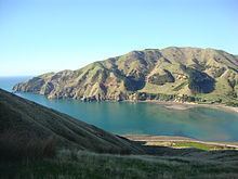
Pepin Island is 3.5 kilometres (2.2 mi) long, and up to 2.1 kilometres (1.3 mi) wide. It measures about 6 square kilometres (2.3 sq mi) in area. The highest point is Stuart Hill, which rises to 399 metres (1,309 ft). The island was named by the French explorer Jules Dumont d'Urville after his wife, Adèle Pépin. The island is located on the northeast coast of Tasman Bay, with the smaller indentation of Delaware Bay to the east.
In 1996, the island was bought by the German businesswoman Dr Viola von Hohenzollern (née Hallman) for NZ$2 million. When von Hohenzollern bought the island, it was overgrazed, run down, and had many wild goats that prevent the growth of native bush. Her farm manager improved the situation by planting trees, fencing and pest control. In December 2012, von Hohenzollern died and Pepin Island was inherited by her daughter. The new owner has introduced public open days, and the second one was run in May 2015, which attracted over 1,000 people and was again a fundraiser for the Hira Volunteer Fire Force.