
Population 215 (2006 census) Postcode(s) 5690 Postal code 5690 | Established 1915 Local time Monday 12:23 AM | |
 | ||
Location 854 km (531 mi) from Adelaide73 km (45 mi) from Ceduna543 km (337 mi) from Port Augusta Weather 22°C, Wind SW at 24 km/h, 92% Humidity | ||
Penong is a small South Australian town on the Nullarbor Plain. Its location on the Eyre Highway makes it a popular rest-stop for travelers.
Map of Penong SA 5690, Australia
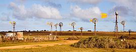
The area surrounding Penong was settled by Europeans in the 19th century, the town being established in 1915 with the arrival of the railway. It is characterised by many windmills, which pump water from the Anjutabie water basin.
Penong is the closest town to the Chadinga Conservation Park and Lake MacDonnell, which has rich reserves of salt and gypsum. The town is 20 km north of Cactus Beach, a popular surfing beach. Cactus Beach is on the western side of Point Sinclair, while Port Le Hunte is on the sheltered eastern side, also known as Port Irvine.
References
Penong, South Australia Wikipedia(Text) CC BY-SA