
Type artificial lake Surface area 112 km (43 sq mi) Max. depth 18 m (59 ft) Surface elevation 270 m | Basin countries Argentina Average depth 9.4 m (31 ft) Area 112 km² Mean depth 9.4 m | |
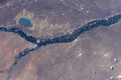 | ||
The Pellegrini Lake is an artificial lake located on the Argentine Patagonia, in the province of Río Negro, near the city of Cinco Saltos, at approximately 38°40′S 68°00′W and 270 m above mean sea level.
Map of Lago Pellegrini, R%C3%ADo Negro, Argentina
This reservoir was originally a natural depressed area, possibly excavated by eolic forces, which was later filled with water brought by a derivation channel from the nearby Neuquén River, in order to regulate its flow (since the river had no natural lakes that would fulfill this function). It has mean and maximum depths of 9.4 and 18 m, respectively. It covers an area of 112 km² and has a volume of 1.053×10⁹ m³.
The lake is employed for commercial fishing of trucha criolla (Percichthys trucha, a species of temperate perch) and pejerrey (Odontesthes microlepidotus, a neotropical silverside), as well as sport fishing, recreation and tourism.