
Founded 1917 Time zone PST (UTC+8) Local time Thursday 1:29 AM | Barangays Area 38.29 km² | |
 | ||
Weather 26°C, Wind E at 5 km/h, 73% Humidity | ||
Peñarrubia, officially the Municipality of Peñarrubia (Ilocano: Ili ti Peñarrubia, Filipino: Bayan ng Peñarrubia), is a municipality in the province of Abra in the Cordillera Administrative Region (CAR) of the Philippines. The population was 6,640 at the 2015 census. In the 2016 electoral roll, it had 4,655 registered voters.
Contents
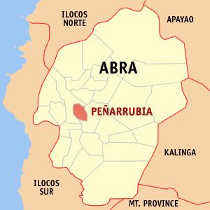
Map of Pe%C3%B1arrubia, Abra, Philippines
Geography
Peñarrubia is located at 17°34′N 120°39′E.
According to the Philippine Statistics Authority, the municipality has a land area of 38.29 square kilometres (14.78 sq mi) constituting 6999920000000000000♠0.92% of the 4,165.25-square-kilometre- (1,608.21 sq mi) total area of Abra.
Barangays
Peñarrubia is politically subdivided into 9 barangays.
Demographics
In the 2015 census, Peñarrubia had a population of 6,640. The population density was 170 inhabitants per square kilometre (440/sq mi).
In the 2016 electoral roll, it had 4,655 registered voters.
Government
Antonio Amasi Domes-ag was OIC Mayor of the town in 1989-1992, then elected as mayor in 1992-1995, and again for the term 1995-1998. He was replaced by his wife Lovelyn Domes-ag in 1998-2001 and 2001-2004. The election of 2004 became controversial in the whole nation when both husband and wife ran for mayoralty candidate. Antonio Domes-ag was proclaimed as the winner. In the May 2007 election, incumbent Vice-Mayor Geraldine Mamsaang-Balbuena won in a matter of one vote against Antonio A. Domes-ag.
The present municipal mayor is still Geraldine Mamsaang-Balbuena.