
Country United States FIPS code 29-56558 Elevation 238 m Zip code 64670 Local time Friday 2:43 PM | Time zone Central (CST) (UTC-6) GNIS feature ID 0730175 Area 158 ha Population 340 (2013) Area code 660 | |
 | ||
Weather 14°C, Wind SE at 6 km/h, 96% Humidity | ||
Pattonsburg is a city in Daviess County, Missouri. The population was 348 at the 2010 census.
Contents
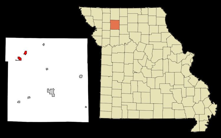
Map of Pattonsburg, MO 64670, USA
History
Pattonsburg on its current site had its start in the 1870s when the railroad was extended to that point. The previous town, now known as Old Pattonsburg, was bypassed by the railroad.
Geography
Pattonsburg is located at 40°3′16″N 94°7′29″W (40.054571, -94.124625). According to the United States Census Bureau, the city has a total area of 0.61 square miles (1.58 km2), all of it land.
2010 census
As of the census of 2010, there were 348 people, 99 households, and 59 families residing in the city. The population density was 570.5 inhabitants per square mile (220.3/km2). There were 118 housing units at an average density of 193.4 per square mile (74.7/km2). The racial makeup of the city was 95.1% White, 2.6% African American, 1.4% Native American, and 0.9% from two or more races. Hispanic or Latino of any race were 2.9% of the population.
There were 99 households of which 30.3% had children under the age of 18 living with them, 47.5% were married couples living together, 8.1% had a female householder with no husband present, 4.0% had a male householder with no wife present, and 40.4% were non-families. 34.3% of all households were made up of individuals and 18.2% had someone living alone who was 65 years of age or older. The average household size was 2.28 and the average family size was 3.03.
The median age in the city was 34.2 years. 17.8% of residents were under the age of 18; 12.1% were between the ages of 18 and 24; 34.2% were from 25 to 44; 22.4% were from 45 to 64; and 13.5% were 65 years of age or older. The gender makeup of the city was 60.1% male and 39.9% female.
2000 census
As of the census of 2000, there were 261 people, 120 households, and 75 families residing in the city. The population density was 194.5 people per square mile (75.2/km²). There were 134 housing units at an average density of 99.8 per square mile (38.6/km²). The racial makeup of the city was 98.85% White, 0.38% Asian, and 0.77% from two or more races. Hispanic or Latino of any race were 1.53% of the population.
There were 120 households out of which 32.5% had children under the age of 18 living with them, 44.2% were married couples living together, 15.0% had a female householder with no husband present, and 37.5% were non-families. 35.0% of all households were made up of individuals and 15.8% had someone living alone who was 65 years of age or older. The average household size was 2.18 and the average family size was 2.80.
In the city the population was spread out with 25.7% under the age of 18, 9.6% from 18 to 24, 23.4% from 25 to 44, 22.6% from 45 to 64, and 18.8% who were 65 years of age or older. The median age was 41 years. For every 100 females there were 78.8 males. For every 100 females age 18 and over, there were 79.6 males.
The median income for a household in the city was $30,500, and the median income for a family was $41,875. Males had a median income of $23,750 versus $18,125 for females. The per capita income for the city was $20,779. About 20.3% of families and 26.3% of the population were below the poverty line, including 42.5% of those under the age of eighteen and 19.6% of those sixty five or over.