
Area 537.8 km² Number of airports 1 | Local time Friday 11:03 AM | |
 | ||
Weather 23°C, Wind N at 6 km/h, 68% Humidity University Universidade Tecnológica Federal do Paraná, Pato Branco | ||
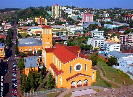
Pato Branco ("White Duck" in English) is a city in the southwest part of the Brazilian state Paraná. The municipality covers 537,8 km² (206.7 mi²) and has a population of 66,680 (2007 IBGE estimate). Pato Branco started off as a village in 1942 and was given status as a city December 14th 1952. It has two private colleges, Faculdade Mater Dei and Faculdade de Pato Branco, and one public University, Universidade Tecnológica Federal do Paraná (The Federal Technologic University of Paraná). The city has experienced a positive economic development throughout the last few years.
Map of Pato Branco, Paran%C3%A1, Brazil
Pato Branco is located 760 meters above sea level and has a sub-tropical climate with warm summers and mild winters, morning frost being usual during the winter season. Occasional snowfall. There is no defined period of drought. The coldest month of the year is July with an average temperature of 14.2°C (57.6°F). January is the warmest month with an average of 22.5°C (72.5°F).
The current mayor (elected for 2013-2016) is Augustinho Zucchi.
The city has a small general aviation airport (Juvenal Loureiro Cardoso Airport).