
Country United States FIPS code 39-61112 Elevation 305 m Local time Friday 6:24 AM Area code 740 | Time zone Eastern (EST) (UTC-5) GNIS feature ID 1049066 Zip code 43062 Population 15,160 (2013) | |
 | ||
Weather 9°C, Wind S at 8 km/h, 52% Humidity Area 74.38 km² (74.13 km² Land / 26 ha Water) | ||
New 2015 jayco eagle travel trailers 318rets for sale in pataskala ohio
Pataskala is a city in Licking County, Ohio, United States. The population was 14,962 at the 2010 census. Pataskala was a small community until 1996, when what was then the village of Pataskala merged with Lima Township, vastly increasing its population and geographic area.
Contents
- New 2015 jayco eagle travel trailers 318rets for sale in pataskala ohio
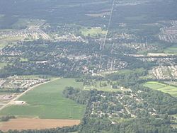
- Map of Pataskala OH USA
- History
- Geography
- 2010 census
- 2000 census
- Notable people
- References
Map of Pataskala, OH, USA
History
Pataskala was laid out in 1851 when the railroad was extended to that point. Pataskala is a name derived from the Delaware language. A post office has been in operation at Pataskala since 1852.
Geography
Pataskala is located at 39°59′52″N 82°41′51″W (39.997890, -82.697411), along the South Fork of the Licking River in Southwestern Licking County. Pataskala is also the home of two school districts, Southwest Licking Local Schools and Licking Heights Local Schools. The Licking Heights district also serves parts of Reynoldsburg, and Jefferson Township as well as the city of Blacklick.
According to the United States Census Bureau, the city has a total area of 28.72 square miles (74.38 km2), of which 28.62 square miles (74.13 km2) is land and 0.10 square miles (0.26 km2) is water.
2010 census
As of the census of 2010, there were 14,962 people, 5,588 households, and 4,132 families residing in the city. The population density was 522.8 inhabitants per square mile (201.9/km2). There were 5,960 housing units at an average density of 208.2 per square mile (80.4/km2). The racial makeup of the city was 90.0% White, 6.0% African American, 0.3% Native American, 0.7% Asian, 0.6% from other races, and 2.5% from two or more races. Hispanic or Latino of any race were 2.0% of the population.
There were 5,588 households of which 39.9% had children under the age of 18 living with them, 56.3% were married couples living together, 12.7% had a female householder with no husband present, 4.9% had a male householder with no wife present, and 26.1% were non-families. 20.6% of all households were made up of individuals and 6.5% had someone living alone who was 65 years of age or older. The average household size was 2.66 and the average family size was 3.07.
The median age in the city was 35.8 years. 27.6% of residents were under the age of 18; 6.8% were between the ages of 18 and 24; 29.9% were from 25 to 44; 25.2% were from 45 to 64; and 10.6% were 65 years of age or older. The gender makeup of the city was 49.1% male and 50.9% female.
2000 census
As of the census of 2000, there were 10,249 people, 3,922 households, and 2,914 families residing in the city. The population density was 359.5 people per square mile (138.8/km²). There were 4,132 housing units at an average density of 144.9 per square mile (56.0/km²). The racial makeup of the city was 94.58% White, 2.96% African American, 0.34% Native American, 0.54% Asian, 0.01% Pacific Islander, 0.56% from other races, and 1.02% from two or more races. Hispanic or Latino of any race were 1.01% of the population.
There were 3,922 households out of which 38.1% had children under the age of 18 living with them, 59.9% were married couples living together, 10.7% had a female householder with no husband present, and 25.7% were non-families. 20.9% of all households were made up of individuals and 7.8% had someone living alone who was 65 years of age or older. The average household size was 2.59 and the average family size was 3.00.
In the city, the population was spread out with 27.8% under the age of 18, 7.1% from 18 to 24, 32.8% from 25 to 44, 22.7% from 45 to 64, and 9.5% who were 65 years of age or older. The median age was 34 years. For every 100 females there were 95.7 males. For every 100 females age 18 and over, there were 92.7 males.
The median income for a household in the city was $51,684, and the median income for a family was $58,021. Males had a median income of $39,322 versus $30,628 for females. The per capita income for the city was $23,099. About 5.0% of families and 5.4% of the population were below the poverty line, including 4.5% of those under age 18 and 9.2% of those age 65 or over.