
Elevation 441 m (1,447 ft) Dialing code 0763 Local time Thursday 7:16 PM Dialling code 0763 | Time zone CET (UTC+1) Area 39.9 km² Postal code 05010 | |
 | ||
Frazioni Cantone, Frattaguida, Pievelunga Weather 13°C, Wind S at 8 km/h, 75% Humidity | ||
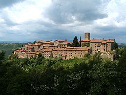
Parrano is a comune (municipality) in the Province of Terni in the Italian region Umbria, located about 35 km southwest of Perugia and about 50 km northwest of Terni. As of 31 December 2004, it had a population of 589 and an area of 39.9 km².
Map of 05010 Parrano Province of Terni, Italy
The municipality of Parrano contains the frazioni (subdivisions, mainly villages and hamlets) Cantone, Frattaguida, and Pievelunga.
Parrano borders the following municipalities: Ficulle, Montegabbione, San Venanzo.
References
Parrano Wikipedia(Text) CC BY-SA